Plombières night lights from space
Night Light of Plombières (Wallonia) from space (Belgium) Src. Average luminocity for 10x10km area is 9.5187% and for 50x50km: 26.2633%.
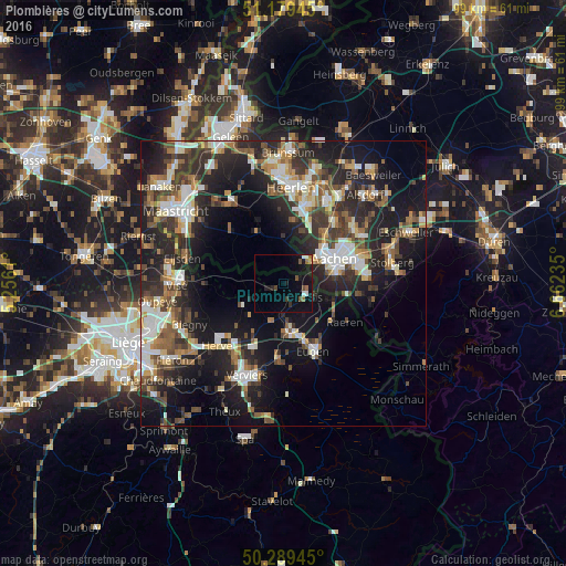
Analysis of Plombières night lights 2016
Square area 10x10 km:
 1.07%
1.07%90-99
1.07%80-89
0%70-79
0.53%60-69
1.87%50-59
1.2%40-49
1.6%30-39
1.2%20-29
1.2%10-19
11.76%0-9
78.48%Square area 50x50 km:
3.77%90-99
5.05%80-89
2.36%70-79
2.39%60-69
3.36%50-59
4.13%40-49
3.89%30-39
4.99%20-29
10.34%10-19
18.36%0-9
41.36%Clear (daylight) street map image can be seen on geolist.org.
Map coordinates:
51° 10' 46" North, 5° 15' 22" East
50° 44' 11.6" North, 5° 57' 33.2" East
50° 17' 22" North, 6° 39' 44.5" East
Some cities around Plombières sort by population:
• Aachen, DE
9.8 km =6.1 mi,  62°
62°
• Würselen, DE
15.3 km =9.5 mi,  53°
53°
• Eupen
13.3 km =8.3 mi,  155°
155°
• La Calamine
4.2 km =2.6 mi,  119°
119°
• Raeren
13.4 km =8.3 mi,  125°
125°
• Welkenraedt
8.5 km =5.3 mi,  174°
174°
• Vaals, NL
5.6 km =3.5 mi, 47°
• Limbourg
13.9 km =8.6 mi,  185°
185°
2788849 (p: 9,596)
Sources (retrieved 2019-11-25):
» Earth at Night: Flat Maps 2012, 2016