Limbourg night lights from space
Night Light of Limbourg (Wallonia) from space (Belgium) Src. Average luminocity for 10x10km area is 24.3676% and for 50x50km: 17.4292%.
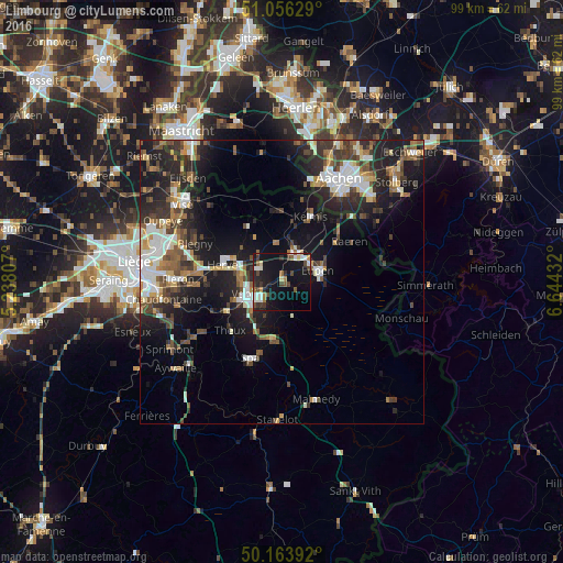
Analysis of Limbourg night lights 2016
Square area 10x10 km:
 3.34%
3.34%90-99
4.14%80-89
1.87%70-79
1.2%60-69
3.07%50-59
2.54%40-49
5.08%30-39
3.61%20-29
4.95%10-19
38.1%0-9
32.09%Square area 50x50 km:
2.59%90-99
3.18%80-89
1.55%70-79
1.32%60-69
2.24%50-59
2.82%40-49
2.73%30-39
3.09%20-29
6.07%10-19
13.21%0-9
61.2%Clear (daylight) street map image can be seen on geolist.org.
Map coordinates:
51° 3' 22.6" North, 5° 14' 17.1" East
50° 36' 44" North, 5° 56' 28.3" East
50° 9' 50.1" North, 6° 38' 39.6" East
Some cities around Limbourg sort by population:
• Verviers
6.1 km =3.8 mi,  245°
245°
• Eupen
6.9 km =4.3 mi,  75°
75°
• Herve
10.9 km =6.8 mi,  286°
286°
• Dison
6.2 km =3.9 mi,  267°
267°
• Theux
12.6 km =7.8 mi,  225°
225°
• Pepinster
10.5 km =6.5 mi, 246°
• Welkenraedt
5.7 km =3.5 mi,  20°
20°
• Jalhay
6.2 km =3.9 mi,  162°
162°
2792348 (p: 5,612)
Sources (retrieved 2019-11-25):
» Earth at Night: Flat Maps 2012, 2016