Pont-à-Celles night lights from space
Night Light of Pont-à-Celles (Wallonia) from space (Belgium) Src. Average luminocity for 10x10km area is 43.6709% and for 50x50km: 34.403%.
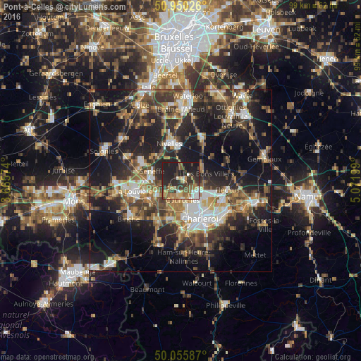
Analysis of Pont-à-Celles night lights 2016
Square area 10x10 km:
 4.06%
4.06%90-99
5.32%80-89
4.48%70-79
5.88%60-69
9.52%50-59
8.12%40-49
6.02%30-39
13.03%20-29
21.01%10-19
22.55%0-9
0%Square area 50x50 km:
4.35%90-99
5.51%80-89
3.35%70-79
4.43%60-69
5.33%50-59
5.68%40-49
6.31%30-39
7.02%20-29
11.47%10-19
22.26%0-9
24.3%Clear (daylight) street map image can be seen on geolist.org.
Map coordinates:
50° 57' 0.9" North, 3° 39' 56.7" East
50° 30' 18.6" North, 4° 22' 7.9" East
50° 3' 21.1" North, 5° 4' 19.2" East
Some cities around Pont-à-Celles sort by population:
• Charleroi
11.7 km =7.3 mi,  152°
152°
• Courcelles
4.6 km =2.9 mi,  174°
174°
• Nivelles
10.7 km =6.6 mi,  344°
344°
• Manage
9.4 km =5.8 mi,  268°
268°
• Morlanwelz-Mariemont
10.4 km =6.5 mi,  237°
237°
• Chapelle-lez-Herlaimont
7.2 km =4.5 mi, 238°
• Seneffe
8 km =5 mi,  291°
291°
• Brunehault
4.5 km =2.8 mi,  89°
89°
2788765 (p: 15,909)
Sources (retrieved 2019-11-25):
» Earth at Night: Flat Maps 2012, 2016