Seneffe night lights from space
Night Light of Seneffe (Wallonia) from space (Belgium) Src. Average luminocity for 10x10km area is 51.4748% and for 50x50km: 35.9745%.
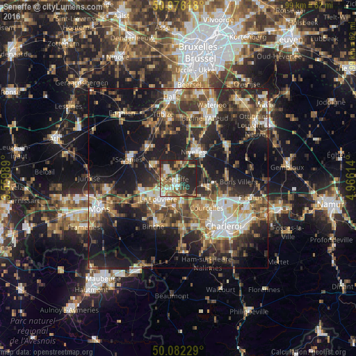
Analysis of Seneffe night lights 2016
Square area 10x10 km:
 7%
7%90-99
9.38%80-89
3.78%70-79
6.86%60-69
11.48%50-59
10.22%40-49
8.4%30-39
7.42%20-29
25.77%10-19
9.66%0-9
0%Square area 50x50 km:
4.6%90-99
5.83%80-89
3.65%70-79
4.69%60-69
5.67%50-59
5.88%40-49
6.17%30-39
7.43%20-29
12.66%10-19
21.64%0-9
21.79%Clear (daylight) street map image can be seen on geolist.org.
Map coordinates:
50° 58' 34.2" North, 3° 33' 35.6" East
50° 31' 52.9" North, 4° 15' 46.8" East
50° 4' 56.2" North, 4° 57' 58.1" East
Some cities around Seneffe sort by population:
• La Louvière
7.3 km =4.5 mi,  226°
226°
• Courcelles
10.9 km =6.8 mi,  133°
133°
• Nivelles
8.8 km =5.5 mi,  31°
31°
• Manage
3.7 km =2.3 mi,  211°
211°
• Morlanwelz-Mariemont
8.6 km =5.3 mi,  188°
188°
• Pont-à-Celles
8 km =5 mi,  111°
111°
• Chapelle-lez-Herlaimont
6.8 km =4.2 mi,  168°
168°
• Écaussinnes-d’Enghien
8 km =5 mi,  300°
300°
2786852 (p: 11,025)
Sources (retrieved 2019-11-25):
» Earth at Night: Flat Maps 2012, 2016