Morlanwelz-Mariemont night lights from space
Night Light of Morlanwelz-Mariemont (Wallonia) from space (Belgium) Src. Average luminocity for 10x10km area is 61.4944% and for 50x50km: 32.2776%.
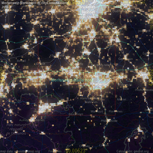
Analysis of Morlanwelz-Mariemont night lights 2016
Square area 10x10 km:
 8.26%
8.26%90-99
10.36%80-89
6.86%70-79
10.5%60-69
11.2%50-59
16.39%40-49
13.59%30-39
18.49%20-29
4.34%10-19
0%0-9
0%Square area 50x50 km:
4.68%90-99
5.48%80-89
3.12%70-79
3.92%60-69
4.85%50-59
5%40-49
5.13%30-39
5.79%20-29
11.14%10-19
20.57%0-9
30.34%Clear (daylight) street map image can be seen on geolist.org.
Map coordinates:
50° 54' 2.1" North, 3° 32' 31.5" East
50° 27' 18.1" North, 4° 14' 42.7" East
50° 0' 18.8" North, 4° 56' 54" East
Some cities around Morlanwelz-Mariemont sort by population:
• La Louvière
5.4 km =3.4 mi,  310°
310°
• Binche
7.5 km =4.7 mi,  229°
229°
• Courcelles
9.2 km =5.7 mi,  83°
83°
• Manage
5.4 km =3.4 mi,  352°
352°
• Pont-à-Celles
10.4 km =6.5 mi,  57°
57°
• Chapelle-lez-Herlaimont
3.2 km =2 mi, 55°
• Anderlues
5.6 km =3.5 mi,  160°
160°
• Seneffe
8.6 km =5.3 mi,  8°
8°
2790697 (p: 18,233)
Sources (retrieved 2019-11-25):
» Earth at Night: Flat Maps 2012, 2016