Nivelles night lights from space
Night Light of Nivelles (Wallonia) from space (Belgium) Src. Average luminocity for 10x10km area is 39.3262% and for 50x50km: 40.2874%.
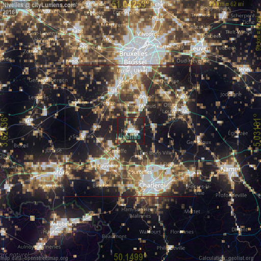
Analysis of Nivelles night lights 2016
Square area 10x10 km:
 4.95%
4.95%90-99
5.88%80-89
3.61%70-79
5.88%60-69
5.21%50-59
2.54%40-49
5.48%30-39
6.42%20-29
28.88%10-19
31.15%0-9
0%Square area 50x50 km:
6%90-99
6.59%80-89
4.03%70-79
5.14%60-69
6.49%50-59
6.55%40-49
6.36%30-39
8.18%20-29
13.79%10-19
23.38%0-9
13.51%Clear (daylight) street map image can be seen on geolist.org.
Map coordinates:
51° 2' 33.1" North, 3° 37' 31.3" East
50° 35' 54" North, 4° 19' 42.5" East
50° 8' 59.6" North, 5° 1' 53.8" East
Some cities around Nivelles sort by population:
• Braine-l'Alleud
9.9 km =6.2 mi,  16°
16°
• Manage
12.4 km =7.7 mi,  211°
211°
• Pont-à-Celles
10.7 km =6.6 mi,  164°
164°
• Genappe
8.8 km =5.5 mi,  80°
80°
• Seneffe
8.8 km =5.5 mi, 211°
• Écaussinnes-d’Enghien
12 km =7.5 mi,  253°
253°
• Braine-le-Château
9.9 km =6.2 mi,  336°
336°
• Ittre
6.8 km =4.2 mi,  318°
318°
2790101 (p: 24,149)
Sources (retrieved 2019-11-25):
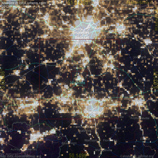
» Earth at Night: Flat Maps 2012, 2016