Chapelle-lez-Herlaimont night lights from space
Night Light of Chapelle-lez-Herlaimont (Wallonia) from space (Belgium) Src. Average luminocity for 10x10km area is 57.1821% and for 50x50km: 32.8071%.
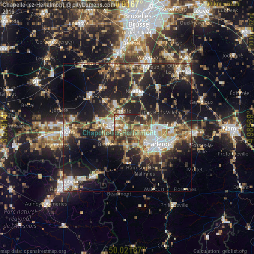
Analysis of Chapelle-lez-Herlaimont night lights 2016
Square area 10x10 km:
 4.2%
4.2%90-99
7%80-89
5.18%70-79
12.18%60-69
16.81%50-59
14.85%40-49
13.59%30-39
14.57%20-29
11.48%10-19
0.14%0-9
0%Square area 50x50 km:
4.59%90-99
5.45%80-89
3.18%70-79
4.09%60-69
5.04%50-59
5.06%40-49
5.58%30-39
6%20-29
11.39%10-19
20.58%0-9
29.03%Clear (daylight) street map image can be seen on geolist.org.
Map coordinates:
50° 55' 0.1" North, 3° 34' 44.9" East
50° 28' 16.7" North, 4° 16' 56.2" East
50° 1' 18" North, 4° 59' 7.4" East
Some cities around Chapelle-lez-Herlaimont sort by population:
• La Louvière
6.9 km =4.3 mi,  284°
284°
• Binche
10.7 km =6.6 mi,  231°
231°
• Courcelles
6.6 km =4.1 mi,  97°
97°
• Manage
4.8 km =3 mi,  317°
317°
• Morlanwelz-Mariemont
3.2 km =2 mi,  235°
235°
• Pont-à-Celles
7.2 km =4.5 mi,  58°
58°
• Anderlues
7.2 km =4.5 mi,  186°
186°
• Seneffe
6.8 km =4.2 mi,  348°
348°
2800500 (p: 14,353)
Sources (retrieved 2019-11-25):
» Earth at Night: Flat Maps 2012, 2016