Brunehault night lights from space
Night Light of Brunehault (Wallonia) from space (Belgium) Src. Average luminocity for 10x10km area is 48.3445% and for 50x50km: 33.4025%.
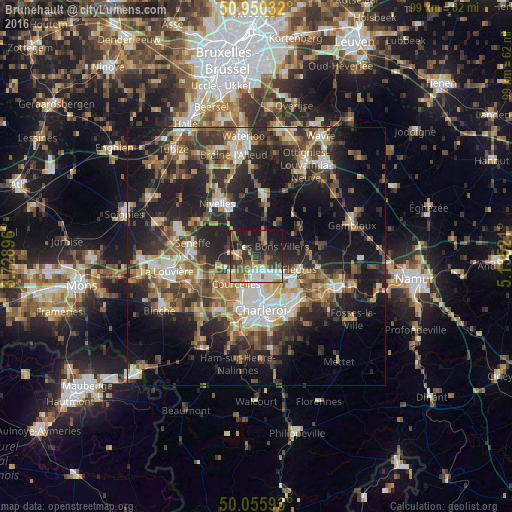
Analysis of Brunehault night lights 2016
Square area 10x10 km:
 8.12%
8.12%90-99
9.66%80-89
3.22%70-79
3.78%60-69
10.08%50-59
9.38%40-49
5.46%30-39
12.89%20-29
16.25%10-19
19.89%0-9
1.26%Square area 50x50 km:
4.21%90-99
5.26%80-89
3.29%70-79
4.38%60-69
5.12%50-59
5.46%40-49
6.1%30-39
7.13%20-29
11.42%10-19
20.82%0-9
26.82%Clear (daylight) street map image can be seen on geolist.org.
Map coordinates:
50° 57' 1.2" North, 3° 43' 44.3" East
50° 30' 18.9" North, 4° 25' 55.5" East
50° 3' 21.3" North, 5° 8' 6.8" East
Some cities around Brunehault sort by population:
• Charleroi
10.5 km =6.5 mi,  175°
175°
• Courcelles
6.1 km =3.8 mi,  221°
221°
• Fleurus
8.7 km =5.4 mi,  106°
106°
• Pont-à-Celles
4.5 km =2.8 mi,  269°
269°
• Chapelle-lez-Herlaimont
11.3 km =7 mi,  250°
250°
• Genappe
11.9 km =7.4 mi,  6°
6°
• Farciennes
11.4 km =7.1 mi,  137°
137°
• Villers-la-Ville
9.1 km =5.7 mi,  41°
41°
2800883 (p: 7,592)
Sources (retrieved 2019-11-25):
» Earth at Night: Flat Maps 2012, 2016