Olen night lights from space
Night Light of Olen (Flanders) from space (Belgium) Src. Average luminocity for 10x10km area is 44.4144% and for 50x50km: 31.0741%.
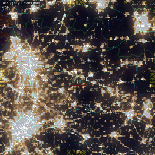
Analysis of Olen night lights 2016
Square area 10x10 km:
 5.88%
5.88%90-99
8.42%80-89
2.27%70-79
3.48%60-69
8.96%50-59
7.89%40-49
8.82%30-39
5.61%20-29
28.61%10-19
20.05%0-9
0%Square area 50x50 km:
2.8%90-99
3.39%80-89
2.78%70-79
3.62%60-69
4.7%50-59
6.68%40-49
6.94%30-39
6.84%20-29
11.58%10-19
28.52%0-9
22.15%Clear (daylight) street map image can be seen on geolist.org.
Map coordinates:
51° 34' 58.5" North, 4° 9' 24" East
51° 8' 38.1" North, 4° 51' 35.3" East
50° 42' 2.4" North, 5° 33' 46.5" East
Some cities around Olen sort by population:
• Geel
9.3 km =5.8 mi,  75°
75°
• Herentals
4.1 km =2.5 mi,  332°
332°
• Westerlo
7.1 km =4.4 mi,  146°
146°
• Herselt
10.4 km =6.5 mi,  171°
171°
• Grobbendonk
10.1 km =6.3 mi,  300°
300°
• Hulshout
9.1 km =5.7 mi,  211°
211°
• Herenthout
7.3 km =4.5 mi,  266°
266°
• Vorselaar
8.9 km =5.5 mi,  316°
316°
2789886 (p: 11,070)
Sources (retrieved 2019-11-25):
» Earth at Night: Flat Maps 2012, 2016