Hulshout night lights from space
Night Light of Hulshout (Flanders) from space (Belgium) Src. Average luminocity for 10x10km area is 37.9559% and for 50x50km: 38.6244%.
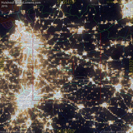
Analysis of Hulshout night lights 2016
Square area 10x10 km:
 2.01%
2.01%90-99
4.81%80-89
3.34%70-79
4.68%60-69
5.21%50-59
8.82%40-49
10.43%30-39
6.02%20-29
22.33%10-19
32.35%0-9
0%Square area 50x50 km:
6.52%90-99
6.35%80-89
3.62%70-79
4.4%60-69
5.66%50-59
6.79%40-49
7.1%30-39
6.96%20-29
10.7%10-19
22.56%0-9
19.34%Clear (daylight) street map image can be seen on geolist.org.
Map coordinates:
51° 30' 51" North, 4° 5' 15.6" East
51° 4' 28.2" North, 4° 47' 26.9" East
50° 37' 50.2" North, 5° 29' 38.1" East
Some cities around Hulshout sort by population:
• Heist-op-den-Berg
4.4 km =2.7 mi,  271°
271°
• Aarschot
10.2 km =6.3 mi,  161°
161°
• Westerlo
8.9 km =5.5 mi,  78°
78°
• Herselt
6.9 km =4.3 mi,  111°
111°
• Olen
9.1 km =5.7 mi,  31°
31°
• Berlaar
10.4 km =6.5 mi,  297°
297°
• Begijnendijk
6.1 km =3.8 mi,  184°
184°
• Herenthout
7.7 km =4.8 mi,  341°
341°
2795170 (p: 9,198)
Sources (retrieved 2019-11-25):
» Earth at Night: Flat Maps 2012, 2016