Herenthout night lights from space
Night Light of Herenthout (Flanders) from space (Belgium) Src. Average luminocity for 10x10km area is 31.7032% and for 50x50km: 39.0647%.
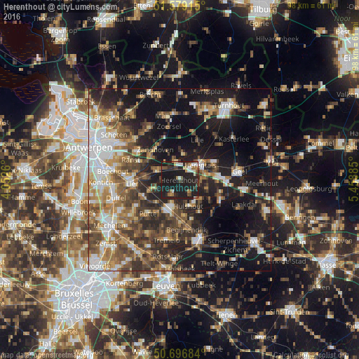
Analysis of Herenthout night lights 2016
Square area 10x10 km:
 3.48%
3.48%90-99
4.68%80-89
2.27%70-79
2.41%60-69
4.28%50-59
3.61%40-49
4.14%30-39
4.01%20-29
17.38%10-19
53.61%0-9
0.13%Square area 50x50 km:
6.37%90-99
6.12%80-89
3.88%70-79
4.69%60-69
5.76%50-59
7.24%40-49
7.24%30-39
6.56%20-29
10.77%10-19
24.41%0-9
16.98%Clear (daylight) street map image can be seen on geolist.org.
Map coordinates:
51° 34' 44.9" North, 4° 3' 9.4" East
51° 8' 24.4" North, 4° 45' 20.6" East
50° 41' 48.6" North, 5° 27' 31.9" East
Some cities around Herenthout sort by population:
• Heist-op-den-Berg
7.4 km =4.6 mi,  194°
194°
• Nijlen
6.4 km =4 mi,  291°
291°
• Zandhoven
10.6 km =6.6 mi,  321°
321°
• Olen
7.3 km =4.5 mi,  86°
86°
• Grobbendonk
5.8 km =3.6 mi,  345°
345°
• Berlaar
7.2 km =4.5 mi,  249°
249°
• Hulshout
7.7 km =4.8 mi,  161°
161°
• Vorselaar
7 km =4.3 mi,  9°
9°
2796005 (p: 8,378)
Sources (retrieved 2019-11-25):
» Earth at Night: Flat Maps 2012, 2016