Grobbendonk night lights from space
Night Light of Grobbendonk (Flanders) from space (Belgium) Src. Average luminocity for 10x10km area is 26.9372% and for 50x50km: 37.5223%.
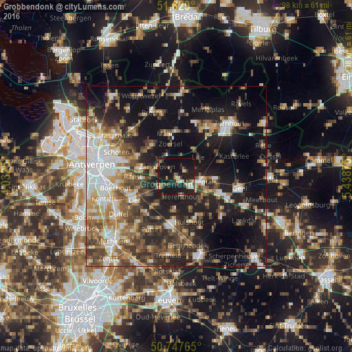
Analysis of Grobbendonk night lights 2016
Square area 10x10 km:
 2.14%
2.14%90-99
2.67%80-89
4.28%70-79
2.41%60-69
1.6%50-59
4.55%40-49
3.88%30-39
3.61%20-29
9.36%10-19
54.28%0-9
11.23%Square area 50x50 km:
6.46%90-99
5.98%80-89
3.8%70-79
4.4%60-69
5.44%50-59
6.53%40-49
6.73%30-39
5.83%20-29
10.14%10-19
23.83%0-9
20.87%Clear (daylight) street map image can be seen on geolist.org.
Map coordinates:
51° 37' 44.4" North, 4° 1' 57" East
51° 11' 25.5" North, 4° 44' 8.2" East
50° 44' 51.5" North, 5° 26' 19.5" East
Some cities around Grobbendonk sort by population:
• Herentals
6.9 km =4.3 mi,  102°
102°
• Nijlen
5.6 km =3.5 mi,  234°
234°
• Zoersel
8.8 km =5.5 mi,  349°
349°
• Lille
8.4 km =5.2 mi,  46°
46°
• Zandhoven
5.8 km =3.6 mi,  297°
297°
• Berlaar
9.7 km =6 mi,  213°
213°
• Herenthout
5.8 km =3.6 mi,  165°
165°
• Vorselaar
2.9 km =1.8 mi,  62°
62°
2797094 (p: 10,724)
Sources (retrieved 2019-11-25):
» Earth at Night: Flat Maps 2012, 2016