Vorselaar night lights from space
Night Light of Vorselaar (Flanders) from space (Belgium) Src. Average luminocity for 10x10km area is 29.3894% and for 50x50km: 34.1351%.
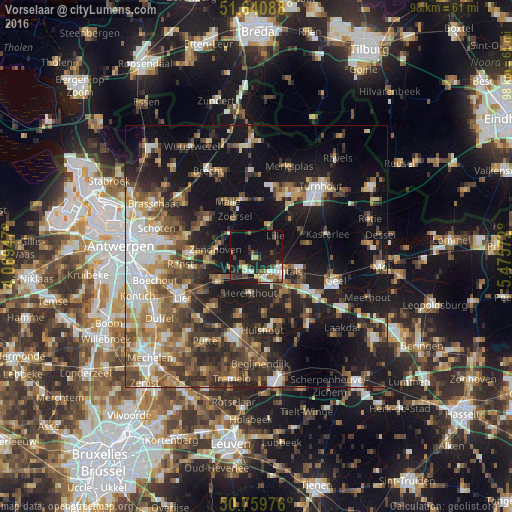
Analysis of Vorselaar night lights 2016
Square area 10x10 km:
 3.92%
3.92%90-99
4.48%80-89
3.92%70-79
0.84%60-69
2.8%50-59
4.48%40-49
5.74%30-39
3.5%20-29
9.24%10-19
39.22%0-9
21.85%Square area 50x50 km:
5.21%90-99
5.1%80-89
3.47%70-79
3.97%60-69
4.85%50-59
5.88%40-49
6.31%30-39
5.6%20-29
10.17%10-19
25.47%0-9
23.98%Clear (daylight) street map image can be seen on geolist.org.
Map coordinates:
51° 38' 27.2" North, 4° 4' 10.1" East
51° 12' 8.7" North, 4° 46' 21.3" East
50° 45' 35.1" North, 5° 28' 32.6" East
Some cities around Vorselaar sort by population:
• Herentals
5.1 km =3.2 mi,  124°
124°
• Nijlen
8.5 km =5.3 mi,  237°
237°
• Zoersel
8.4 km =5.2 mi,  330°
330°
• Lille
5.6 km =3.5 mi,  38°
38°
• Zandhoven
7.9 km =4.9 mi,  280°
280°
• Olen
8.9 km =5.5 mi,  136°
136°
• Grobbendonk
2.9 km =1.8 mi, 242°
• Herenthout
7 km =4.3 mi,  189°
189°
2784370 (p: 7,238)
Sources (retrieved 2019-11-25):
» Earth at Night: Flat Maps 2012, 2016