Herselt night lights from space
Night Light of Herselt (Flanders) from space (Belgium) Src. Average luminocity for 10x10km area is 18.3917% and for 50x50km: 31.5709%.
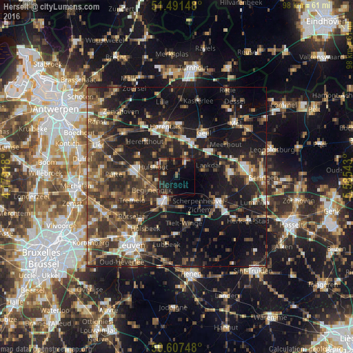
Analysis of Herselt night lights 2016
Square area 10x10 km:
 0.53%
0.53%90-99
2.14%80-89
0%70-79
1.74%60-69
2.41%50-59
3.34%40-49
3.48%30-39
3.61%20-29
10.43%10-19
31.02%0-9
41.31%Square area 50x50 km:
2.91%90-99
3.82%80-89
2.55%70-79
3.32%60-69
4.54%50-59
6.59%40-49
7.67%30-39
7.76%20-29
12.14%10-19
26.43%0-9
22.27%Clear (daylight) street map image can be seen on geolist.org.
Map coordinates:
51° 29' 29.3" North, 4° 10' 45" East
51° 3' 5.7" North, 4° 52' 56.3" East
50° 36' 26.9" North, 5° 35' 7.5" East
Some cities around Herselt sort by population:
• Heist-op-den-Berg
11.1 km =6.9 mi,  283°
283°
• Aarschot
7.8 km =4.8 mi,  203°
203°
• Westerlo
4.9 km =3 mi,  28°
28°
• Diest
13.7 km =8.5 mi,  120°
120°
• Olen
10.4 km =6.5 mi,  351°
351°
• Hulshout
6.9 km =4.3 mi,  291°
291°
• Begijnendijk
7.8 km =4.8 mi,  242°
242°
• Herenthout
13.2 km =8.2 mi,  318°
318°
2795933 (p: 13,493)
Sources (retrieved 2019-11-25):
» Earth at Night: Flat Maps 2012, 2016