Gesves night lights from space
Night Light of Gesves (Wallonia) from space (Belgium) Src. Average luminocity for 10x10km area is 3.1821% and for 50x50km: 12.4866%.
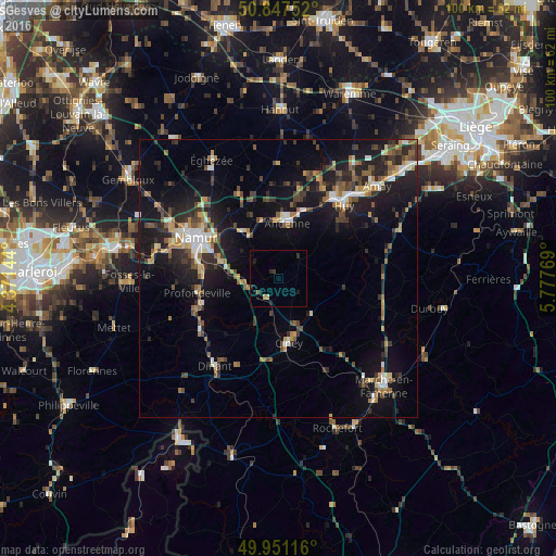
Analysis of Gesves night lights 2016
Square area 10x10 km:
100  0%
0%
90-99 0%
80-89 0.56%
70-79 0.56%
60-69 0%
50-59 0.14%
40-49 0.42%
30-39 0.56%
20-29 2.1%
10-19 2.24%
0-9 93.42%
0%90-99
0%80-89
0.56%70-79
0.56%60-69
0%50-59
0.14%40-49
0.42%30-39
0.56%20-29
2.1%10-19
2.24%0-9
93.42%Square area 50x50 km:
100 1.14%
90-99 1.49%
80-89 1.14%
70-79 1.41%
60-69 1.66%
50-59 1.84%
40-49 2.37%
30-39 2.12%
20-29 4.28%
10-19 11.13%
0-9 71.42%
1.14%90-99
1.49%80-89
1.14%70-79
1.41%60-69
1.66%50-59
1.84%40-49
2.37%30-39
2.12%20-29
4.28%10-19
11.13%0-9
71.42%Clear (daylight) street map image can be seen on geolist.org.
Map coordinates:
50° 50' 51.1" North, 4° 22' 17.2" East
50° 24' 5.3" North, 5° 4' 28.5" East
49° 57' 4.2" North, 5° 46' 39.7" East
Some cities around Gesves sort by population:
• Namur
16.4 km =10.2 mi,  296°
296°
• Andenne
9.9 km =6.2 mi,  8°
8°
• Ciney
12 km =7.5 mi,  171°
171°
• Profondeville
15.1 km =9.4 mi,  259°
259°
• Yvoir
16 km =9.9 mi,  239°
239°
• Hamois
8.9 km =5.5 mi,  139°
139°
• Assesse
5.2 km =3.2 mi,  226°
226°
• Marchin
14 km =8.7 mi,  58°
58°
2797581 (p: 6,150)
Sources (retrieved 2019-11-25):
» Earth at Night: Flat Maps 2012, 2016