Assesse night lights from space
Night Light of Assesse (Wallonia) from space (Belgium) Src. Average luminocity for 10x10km area is 7.1246% and for 50x50km: 12.5494%.
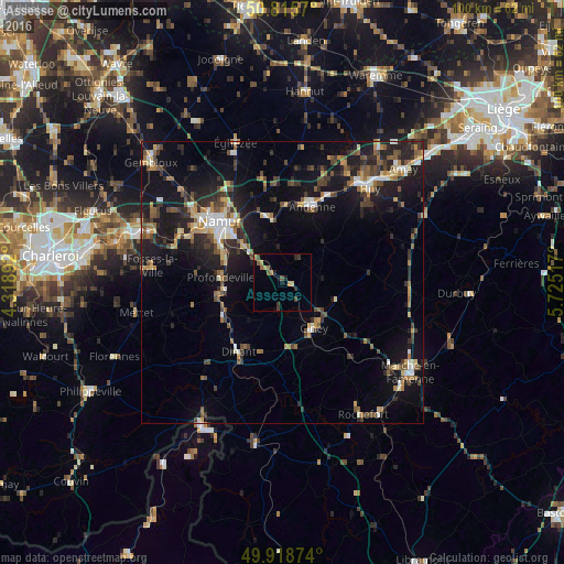
Analysis of Assesse night lights 2016
Square area 10x10 km:
100  0%
0%
90-99 0%
80-89 0.56%
70-79 1.82%
60-69 1.54%
50-59 1.82%
40-49 1.26%
30-39 1.68%
20-29 1.4%
10-19 1.4%
0-9 88.52%
0%90-99
0%80-89
0.56%70-79
1.82%60-69
1.54%50-59
1.82%40-49
1.26%30-39
1.68%20-29
1.4%10-19
1.4%0-9
88.52%Square area 50x50 km:
100 1.04%
90-99 1.52%
80-89 1.12%
70-79 1.53%
60-69 1.71%
50-59 1.96%
40-49 2.44%
30-39 2.13%
20-29 4.12%
10-19 11.4%
0-9 71.02%
1.04%90-99
1.52%80-89
1.12%70-79
1.53%60-69
1.71%50-59
1.96%40-49
2.44%30-39
2.13%20-29
4.12%10-19
11.4%0-9
71.02%Clear (daylight) street map image can be seen on geolist.org.
Map coordinates:
50° 48' 56.5" North, 4° 19' 8.1" East
50° 22' 9.6" North, 5° 1' 19.3" East
49° 55' 7.5" North, 5° 43' 30.6" East
Some cities around Assesse sort by population:
• Andenne
14.3 km =8.9 mi,  21°
21°
• Ciney
10 km =6.2 mi,  146°
146°
• Dinant
14.6 km =9.1 mi,  212°
212°
• Profondeville
11.2 km =7 mi,  273°
273°
• Yvoir
11 km =6.8 mi,  245°
245°
• Anhée
12.1 km =7.5 mi,  237°
237°
• Hamois
10.1 km =6.3 mi,  108°
108°
• Gesves
5.2 km =3.2 mi,  46°
46°
2803018 (p: 6,279)
Sources (retrieved 2019-11-25):
» Earth at Night: Flat Maps 2012, 2016