Hamois night lights from space
Night Light of Hamois (Wallonia) from space (Belgium) Src. Average luminocity for 10x10km area is 5.7381% and for 50x50km: 10.6583%.
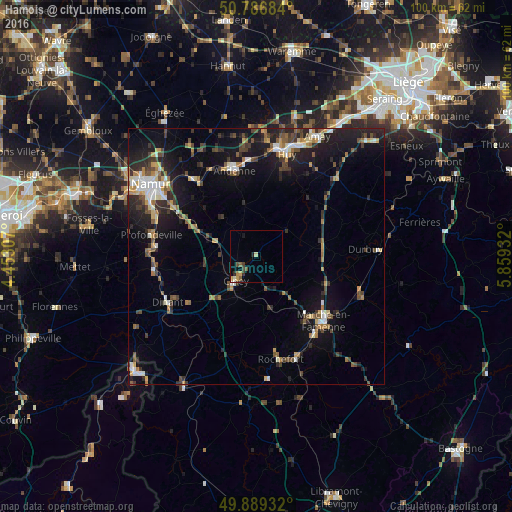
Analysis of Hamois night lights 2016
Square area 10x10 km:
 0%
0%90-99
0.56%80-89
0.56%70-79
1.68%60-69
0.56%50-59
1.4%40-49
1.68%30-39
0.7%20-29
0.7%10-19
1.12%0-9
91.04%Square area 50x50 km:
1.07%90-99
1.39%80-89
0.96%70-79
1.15%60-69
1.53%50-59
1.31%40-49
2.11%30-39
1.7%20-29
3.45%10-19
8.61%0-9
76.72%Clear (daylight) street map image can be seen on geolist.org.
Map coordinates:
50° 47' 12.6" North, 4° 27' 11.1" East
50° 20' 24.7" North, 5° 9' 22.3" East
49° 53' 21.6" North, 5° 51' 33.6" East
Some cities around Hamois sort by population:
• Andenne
17.1 km =10.6 mi,  345°
345°
• Marche-en-Famenne
18.4 km =11.4 mi,  133°
133°
• Ciney
6.5 km =4 mi,  218°
218°
• Dinant
19.6 km =12.2 mi,  242°
242°
• Yvoir
19.6 km =12.2 mi,  266°
266°
• Assesse
10.1 km =6.3 mi,  288°
288°
• Gesves
8.9 km =5.5 mi,  319°
319°
• Marchin
15.4 km =9.6 mi,  23°
23°
2796627 (p: 6,662)
Sources (retrieved 2019-11-25):
» Earth at Night: Flat Maps 2012, 2016