Yvoir night lights from space
Night Light of Yvoir (Wallonia) from space (Belgium) Src. Average luminocity for 10x10km area is 8.6162% and for 50x50km: 12.4401%.
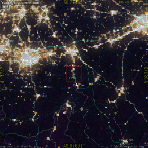
Analysis of Yvoir night lights 2016
Square area 10x10 km:
 0%
0%90-99
1.12%80-89
0%70-79
0.84%60-69
1.4%50-59
2.8%40-49
2.1%30-39
0.14%20-29
2.1%10-19
2.1%0-9
87.39%Square area 50x50 km:
1.13%90-99
1.72%80-89
1.13%70-79
1.52%60-69
1.75%50-59
1.87%40-49
2.38%30-39
2.14%20-29
4.17%10-19
9.86%0-9
72.32%Clear (daylight) street map image can be seen on geolist.org.
Map coordinates:
50° 46' 28.7" North, 4° 10' 38.9" East
50° 19' 40.4" North, 4° 52' 50.1" East
49° 52' 36.9" North, 5° 35' 1.4" East
Some cities around Yvoir sort by population:
• Dinant
8.1 km =5 mi,  164°
164°
• Mettet
15.5 km =9.6 mi,  267°
267°
• Profondeville
5.4 km =3.4 mi,  348°
348°
• Fosses-la-Ville
15.1 km =9.4 mi,  299°
299°
• Floreffe
14.6 km =9.1 mi,  324°
324°
• Anhée
2 km =1.2 mi,  184°
184°
• Assesse
11 km =6.8 mi,  65°
65°
• Hastière-Lavaux
12.8 km =8 mi,  198°
198°
2783385 (p: 8,169)
Sources (retrieved 2019-11-25):
» Earth at Night: Flat Maps 2012, 2016