Ciney night lights from space
Night Light of Ciney (Wallonia) from space (Belgium) Src. Average luminocity for 10x10km area is 9.5254% and for 50x50km: 8.9493%.
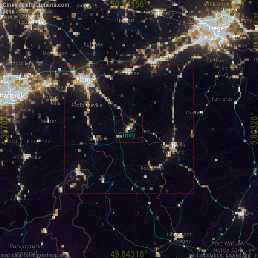
Analysis of Ciney night lights 2016
Square area 10x10 km:
100  0.8%
0.8%
90-99 0.8%
80-89 0%
70-79 2.67%
60-69 1.34%
50-59 1.87%
40-49 2.94%
30-39 1.2%
20-29 0.67%
10-19 0%
0-9 87.7%
0.8%90-99
0.8%80-89
0%70-79
2.67%60-69
1.34%50-59
1.87%40-49
2.94%30-39
1.2%20-29
0.67%10-19
0%0-9
87.7%Square area 50x50 km:
100 0.84%
90-99 1.17%
80-89 0.8%
70-79 1.04%
60-69 1.33%
50-59 1.14%
40-49 1.56%
30-39 1.46%
20-29 2.72%
10-19 6.52%
0-9 81.42%
0.84%90-99
1.17%80-89
0.8%70-79
1.04%60-69
1.33%50-59
1.14%40-49
1.56%30-39
1.46%20-29
2.72%10-19
6.52%0-9
81.42%Clear (daylight) street map image can be seen on geolist.org.
Map coordinates:
50° 44' 29.6" North, 4° 23' 49.3" East
50° 17' 40.2" North, 5° 6' 0.5" East
49° 50' 35.4" North, 5° 48' 11.8" East
Some cities around Ciney sort by population:
• Marche-en-Famenne
18.9 km =11.7 mi,  113°
113°
• Dinant
14 km =8.7 mi,  253°
253°
• Rochefort
17 km =10.6 mi,  149°
149°
• Yvoir
16 km =9.9 mi,  283°
283°
• Anhée
15.9 km =9.9 mi, 276°
• Hamois
6.5 km =4 mi,  38°
38°
• Assesse
10 km =6.2 mi,  326°
326°
• Gesves
12 km =7.5 mi,  351°
351°
2800298 (p: 14,830)
Sources (retrieved 2019-11-25):
» Earth at Night: Flat Maps 2012, 2016