Chièvres night lights from space
Night Light of Chièvres (Wallonia) from space (Belgium) Src. Average luminocity for 10x10km area is 19.4171% and for 50x50km: 24.9828%.
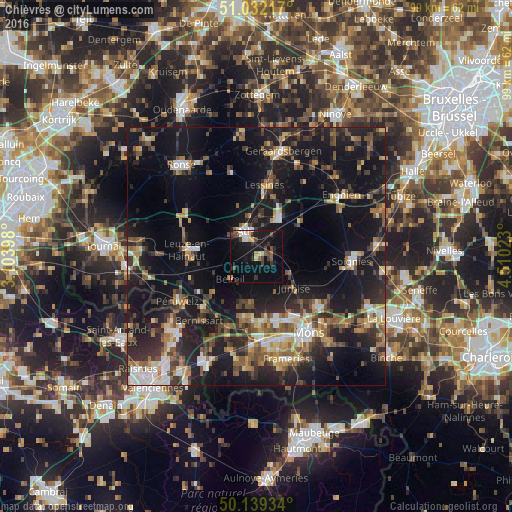
Analysis of Chièvres night lights 2016
Square area 10x10 km:
 1.6%
1.6%90-99
2.94%80-89
1.47%70-79
2.41%60-69
0.13%50-59
2.41%40-49
5.21%30-39
3.21%20-29
3.48%10-19
26.2%0-9
50.94%Square area 50x50 km:
2.25%90-99
3.27%80-89
2.33%70-79
2.77%60-69
3.46%50-59
4.34%40-49
4.65%30-39
4.42%20-29
9.12%10-19
26.26%0-9
37.14%Clear (daylight) street map image can be seen on geolist.org.
Map coordinates:
51° 1' 55.8" North, 3° 6' 14.3" East
50° 35' 16.3" North, 3° 48' 25.6" East
50° 8' 21.6" North, 4° 30' 36.8" East
Some cities around Chièvres sort by population:
• Ath
5.1 km =3.2 mi,  336°
336°
• Saint-Ghislain
15.6 km =9.7 mi,  176°
176°
• Lessines
13.8 km =8.6 mi,  8°
8°
• Beloeil
6.6 km =4.1 mi,  230°
230°
• Bernissart
16.8 km =10.4 mi,  221°
221°
• Frasnes-lez-Buissenal
15.9 km =9.9 mi,  304°
304°
• Jurbise
9.6 km =6 mi,  131°
131°
• Silly
10.7 km =6.6 mi,  50°
50°
2800328 (p: 6,045)
Sources (retrieved 2019-11-25):
» Earth at Night: Flat Maps 2012, 2016