Jurbise night lights from space
Night Light of Jurbise (Wallonia) from space (Belgium) Src. Average luminocity for 10x10km area is 23.1611% and for 50x50km: 26.8652%.
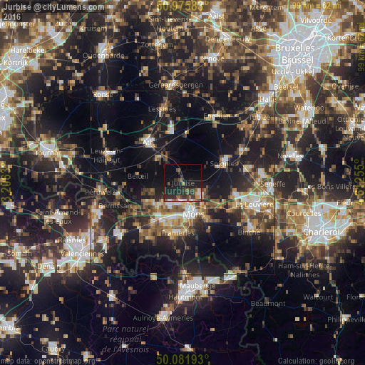
Analysis of Jurbise night lights 2016
Square area 10x10 km:
 1.82%
1.82%90-99
1.82%80-89
1.12%70-79
2.1%60-69
3.22%50-59
3.08%40-49
4.76%30-39
6.44%20-29
16.95%10-19
21.29%0-9
37.39%Square area 50x50 km:
2.62%90-99
3.81%80-89
2.44%70-79
3.41%60-69
3.98%50-59
4.74%40-49
4.84%30-39
4.86%20-29
8.76%10-19
24.15%0-9
36.38%Clear (daylight) street map image can be seen on geolist.org.
Map coordinates:
50° 58' 33" North, 3° 12' 22.7" East
50° 31' 51.6" North, 3° 54' 33.9" East
50° 4' 54.9" North, 4° 36' 45.2" East
Some cities around Jurbise sort by population:
• Mons
9.1 km =5.7 mi,  160°
160°
• Soignies
12.6 km =7.8 mi,  64°
64°
• Saint-Ghislain
11.2 km =7 mi,  214°
214°
• Quaregnon
10.5 km =6.5 mi,  197°
197°
• Beloeil
12.5 km =7.8 mi,  279°
279°
• Silly
13.1 km =8.1 mi,  4°
4°
• Chièvres
9.6 km =6 mi,  311°
311°
• Chasse Royale
11.8 km =7.3 mi,  165°
165°
2794852 (p: 9,483)
Sources (retrieved 2019-11-25):
» Earth at Night: Flat Maps 2012, 2016