Silly night lights from space
Night Light of Silly (Wallonia) from space (Belgium) Src. Average luminocity for 10x10km area is 11.4893% and for 50x50km: 30.4468%.
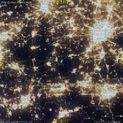
Analysis of Silly night lights 2016
Square area 10x10 km:
100  2.14%
2.14%
90-99 1.47%
80-89 1.07%
70-79 0.8%
60-69 1.2%
50-59 0.94%
40-49 1.2%
30-39 1.34%
20-29 3.21%
10-19 9.89%
0-9 76.74%
2.14%90-99
1.47%80-89
1.07%70-79
0.8%60-69
1.2%50-59
0.94%40-49
1.2%30-39
1.34%20-29
3.21%10-19
9.89%0-9
76.74%Square area 50x50 km:
100 3.06%
90-99 4.31%
80-89 2.66%
70-79 3.89%
60-69 4.47%
50-59 5.99%
40-49 6.11%
30-39 6.04%
20-29 10.06%
10-19 24.79%
0-9 28.62%
3.06%90-99
4.31%80-89
2.66%70-79
3.89%60-69
4.47%50-59
5.99%40-49
6.11%30-39
6.04%20-29
10.06%10-19
24.79%0-9
28.62%Clear (daylight) street map image can be seen on geolist.org.
Map coordinates:
51° 5' 33" North, 3° 13' 13.8" East
50° 38' 55.6" North, 3° 55' 25.1" East
50° 12' 3" North, 4° 37' 36.3" East
Some cities around Silly sort by population:
• Ath
10.5 km =6.5 mi,  258°
258°
• Soignies
13 km =8.1 mi,  126°
126°
• Lessines
9.3 km =5.8 mi,  318°
318°
• Enghien
8.6 km =5.3 mi,  63°
63°
• Rebecq-Rognon
12.9 km =8 mi,  88°
88°
• Galmaarden
12.2 km =7.6 mi,  15°
15°
• Herne
11.5 km =7.1 mi,  43°
43°
• Chièvres
10.7 km =6.6 mi,  230°
230°
2786769 (p: 7,887)
Sources (retrieved 2019-11-25):
» Earth at Night: Flat Maps 2012, 2016