Saint-Ghislain night lights from space
Night Light of Saint-Ghislain (Wallonia) from space (Belgium) Src. Average luminocity for 10x10km area is 63.7829% and for 50x50km: 26.8898%.
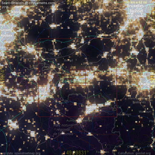

Analysis of Saint-Ghislain night lights 2016
Square area 10x10 km:
 8.12%
8.12%90-99
12.61%80-89
10.08%70-79
10.92%60-69
11.62%50-59
17.51%40-49
10.22%30-39
5.04%20-29
12.61%10-19
1.26%0-9
0%Square area 50x50 km:
3.56%90-99
4.34%80-89
2.5%70-79
2.83%60-69
3.44%50-59
4.08%40-49
4.39%30-39
4.45%20-29
9.4%10-19
22.61%0-9
38.42%Clear (daylight) street map image can be seen on geolist.org.
Map coordinates:
50° 53' 37.6" North, 3° 6' 56.7" East
50° 26' 53.4" North, 3° 49' 7.9" East
49° 59' 53.9" North, 4° 31' 19.2" East
Some cities around Saint-Ghislain sort by population:
• Mons
9.5 km =5.9 mi,  85°
85°
• Frameries
7.2 km =4.5 mi,  130°
130°
• Boussu
2.3 km =1.4 mi,  228°
228°
• Colfontaine
4.6 km =2.9 mi,  145°
145°
• Quaregnon
3.4 km =2.1 mi,  104°
104°
• Dour
6.5 km =4 mi,  206°
206°
• Hensies
9.7 km =6 mi,  259°
259°
• Chasse Royale
9.5 km =5.9 mi, 103°
2787416 (p: 22,500)
Sources (retrieved 2019-11-25):
» Earth at Night: Flat Maps 2012, 2016