Bernissart night lights from space
Night Light of Bernissart (Wallonia) from space (Belgium) Src. Average luminocity for 10x10km area is 31.6947% and for 50x50km: 28.9484%.
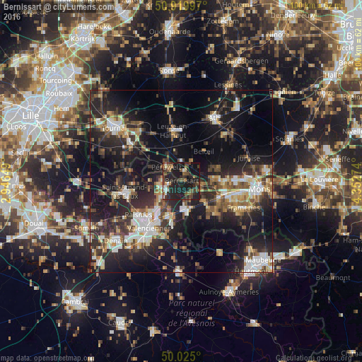
Analysis of Bernissart night lights 2016
Square area 10x10 km:
 2.38%
2.38%90-99
3.5%80-89
0.56%70-79
1.96%60-69
4.06%50-59
6.58%40-49
9.94%30-39
6.72%20-29
19.33%10-19
42.3%0-9
2.66%Square area 50x50 km:
3.97%90-99
4.72%80-89
2.84%70-79
2.73%60-69
3.73%50-59
4.07%40-49
4.81%30-39
5.6%20-29
12.11%10-19
21.26%0-9
34.17%Clear (daylight) street map image can be seen on geolist.org.
Map coordinates:
50° 55' 11.9" North, 2° 56' 47.4" East
50° 28' 28.6" North, 3° 38' 58.6" East
50° 1' 30" North, 4° 21' 9.9" East
Some cities around Bernissart sort by population:
• Péruwelz
5.4 km =3.4 mi,  313°
313°
• Beloeil
10.4 km =6.5 mi,  35°
35°
• Vieux-Condé, FR
6.1 km =3.8 mi,  253°
253°
• Condé-sur-l’Escaut, FR
4.9 km =3 mi,  242°
242°
• Fresnes-sur-Escaut, FR
6.8 km =4.2 mi,  228°
228°
• Quiévrain
7.9 km =4.9 mi,  162°
162°
• Hensies
5.3 km =3.3 mi,  152°
152°
• Quiévrechain, FR
9.3 km =5.8 mi,  171°
171°
2802135 (p: 11,588)
Sources (retrieved 2019-11-25):
» Earth at Night: Flat Maps 2012, 2016