Beloeil night lights from space
Night Light of Beloeil (Wallonia) from space (Belgium) Src. Average luminocity for 10x10km area is 10.3944% and for 50x50km: 25.7334%.
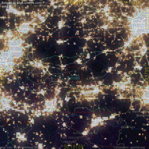
Analysis of Beloeil night lights 2016
Square area 10x10 km:
 0%
0%90-99
0%80-89
0.27%70-79
0.67%60-69
2.01%50-59
1.34%40-49
2.27%30-39
2.41%20-29
2.94%10-19
11.9%0-9
76.2%Square area 50x50 km:
3.08%90-99
3.92%80-89
2.4%70-79
2.59%60-69
3.42%50-59
4.11%40-49
4.4%30-39
4.55%20-29
8.94%10-19
22.6%0-9
39.98%Clear (daylight) street map image can be seen on geolist.org.
Map coordinates:
50° 59' 42.4" North, 3° 1' 54.2" East
50° 33' 1.7" North, 3° 44' 5.4" East
50° 6' 5.7" North, 4° 26' 16.7" East
Some cities around Beloeil sort by population:
• Ath
9.3 km =5.8 mi,  19°
19°
• Saint-Ghislain
12.8 km =8 mi,  152°
152°
• Boussu
13.6 km =8.5 mi,  161°
161°
• Péruwelz
11 km =6.8 mi,  244°
244°
• Bernissart
10.4 km =6.5 mi,  215°
215°
• Jurbise
12.5 km =7.8 mi,  99°
99°
• Hensies
13.6 km =8.5 mi,  195°
195°
• Chièvres
6.6 km =4.1 mi,  50°
50°
2802292 (p: 13,405)
Sources (retrieved 2019-11-25):
» Earth at Night: Flat Maps 2012, 2016