Villers-la-Ville night lights from space
Night Light of Villers-la-Ville (Wallonia) from space (Belgium) Src. Average luminocity for 10x10km area is 17.6377% and for 50x50km: 36.6689%.
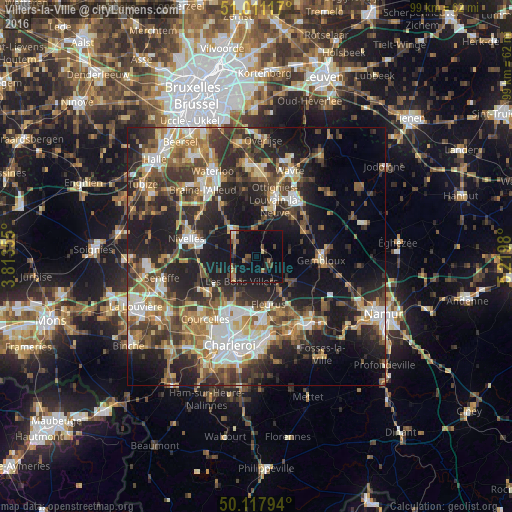
Analysis of Villers-la-Ville night lights 2016
Square area 10x10 km:
 0.4%
0.4%90-99
0.8%80-89
1.6%70-79
1.87%60-69
4.55%50-59
2.81%40-49
3.07%30-39
2.41%20-29
3.88%10-19
23.93%0-9
54.68%Square area 50x50 km:
4.82%90-99
6.2%80-89
3.74%70-79
4.95%60-69
5.82%50-59
5.95%40-49
6.09%30-39
7.91%20-29
12.64%10-19
18.43%0-9
23.45%Clear (daylight) street map image can be seen on geolist.org.
Map coordinates:
51° 0' 40.2" North, 3° 48' 48.8" East
50° 34' 0" North, 4° 31' 0" East
50° 7' 4.6" North, 5° 13' 11.3" East
Some cities around Villers-la-Ville sort by population:
• Fleurus
9.5 km =5.9 mi,  165°
165°
• Genappe
6.8 km =4.2 mi,  317°
317°
• Ottignies
11.5 km =7.1 mi,  17°
17°
• Court-Saint-Étienne
8.3 km =5.2 mi,  26°
26°
• Brunehault
9.1 km =5.7 mi,  221°
221°
• Sombreffe
7.3 km =4.5 mi,  125°
125°
• Mont-Saint-Guibert
10 km =6.2 mi,  41°
41°
• Chastre-Villeroux-Blanmont
10 km =6.2 mi,  62°
62°
2784641 (p: 9,592)
Sources (retrieved 2019-11-25):
» Earth at Night: Flat Maps 2012, 2016