Genappe night lights from space
Night Light of Genappe (Wallonia) from space (Belgium) Src. Average luminocity for 10x10km area is 20.7139% and for 50x50km: 40.2109%.
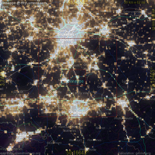
Analysis of Genappe night lights 2016
Square area 10x10 km:
 0.53%
0.53%90-99
1.34%80-89
1.07%70-79
1.87%60-69
3.34%50-59
4.28%40-49
1.74%30-39
2.94%20-29
8.29%10-19
54.68%0-9
19.92%Square area 50x50 km:
6.51%90-99
6.69%80-89
3.89%70-79
5.11%60-69
6.21%50-59
6.63%40-49
6.26%30-39
8.12%20-29
13.22%10-19
21.36%0-9
15.99%Clear (daylight) street map image can be seen on geolist.org.
Map coordinates:
51° 3' 20.9" North, 3° 44' 54.2" East
50° 36' 42.2" North, 4° 27' 5.5" East
50° 9' 48.3" North, 5° 9' 16.7" East
Some cities around Genappe sort by population:
• Braine-l'Alleud
9.9 km =6.2 mi,  323°
323°
• Nivelles
8.8 km =5.5 mi,  260°
260°
• Basse Lasne
9.7 km =6 mi,  17°
17°
• Villers-la-Ville
6.8 km =4.2 mi,  137°
137°
• Ottignies
10.1 km =6.3 mi,  53°
53°
• Court-Saint-Étienne
8.6 km =5.3 mi,  73°
73°
• Brunehault
11.9 km =7.4 mi,  186°
186°
• Mont-Saint-Guibert
11.5 km =7.1 mi,  77°
77°
2797694 (p: 14,266)
Sources (retrieved 2019-11-25):
» Earth at Night: Flat Maps 2012, 2016