Farciennes night lights from space
Night Light of Farciennes (Wallonia) from space (Belgium) Src. Average luminocity for 10x10km area is 70.3571% and for 50x50km: 26.2598%.
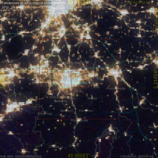
Analysis of Farciennes night lights 2016
Square area 10x10 km:
 16.11%
90-99
20.31%80-89
9.8%70-79
11.06%60-69
7.28%50-59
9.52%40-49
7.7%30-39
5.6%20-29
8.82%10-19
3.78%0-9
0%Square area 50x50 km:
3.4%90-99
4.16%80-89
2.55%70-79
3.39%60-69
4.06%50-59
4.06%40-49
4.64%30-39
4.86%20-29
9.06%10-19
16.65%0-9
43.19%Clear (daylight) street map image can be seen on geolist.org.
Map coordinates:
50° 52' 33.1" North, 3° 50' 18.2" East
50° 25' 48.2" North, 4° 32' 29.5" East
49° 58' 48.1" North, 5° 14' 40.7" East
Some cities around Farciennes sort by population:
• Charleroi
7.2 km =4.5 mi,  253°
253°
• Châtelet
3.1 km =1.9 mi,  197°
197°
• Fleurus
6 km =3.7 mi,  5°
5°
• Gerpinnes
10.3 km =6.4 mi,  185°
185°
• Aiseau
3.8 km =2.4 mi,  122°
122°
• Fosses-la-Ville
11.6 km =7.2 mi,  109°
109°
• La Bruyère
6.5 km =4 mi,  127°
127°
• Brunehault
11.4 km =7.1 mi,  317°
317°
2798470 (p: 11,488)
Sources (retrieved 2019-11-25):
» Earth at Night: Flat Maps 2012, 2016