Qobustan night lights from space
Night Light of Qobustan (Baki) from space (Azerbaijan) Src. Average luminocity for 10x10km area is 16.7857% and for 50x50km: 5.724%.
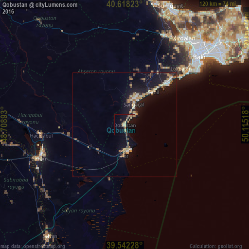
Analysis of Qobustan night lights 2016
Square area 10x10 km:
 0.32%
0.32%90-99
1.3%80-89
4.87%70-79
2.6%60-69
2.27%50-59
0.32%40-49
4.38%30-39
1.46%20-29
1.3%10-19
15.91%0-9
65.26%Square area 50x50 km:
0.38%90-99
0.68%80-89
0.8%70-79
0.87%60-69
0.82%50-59
0.59%40-49
0.77%30-39
0.7%20-29
1.26%10-19
6.94%0-9
86.17%Clear (daylight) street map image can be seen on geolist.org.
Map coordinates:
40° 37' 5.6" North, 48° 42' 32.1" East
40° 4' 56.6" North, 49° 24' 43.4" East
39° 32' 32.2" North, 50° 6' 54.6" East
Some cities around Qobustan sort by population:
• Şirvan
44.2 km =27.5 mi,  248°
248°
• Bilajari
52.3 km =32.5 mi,  39°
39°
• Khirdalan
50 km =31.1 mi, 35°
• Lökbatan
38.4 km =23.9 mi,  45°
45°
• Hacıqabul
40.2 km =25 mi,  263°
263°
• Badamdar
44 km =27.3 mi, 49°
• Qobu
44 km =27.3 mi, 35°
• Khodzhi-Gasan
47.6 km =29.6 mi, 39°
585223 (p: 13,398)
Sources (retrieved 2019-11-25):
» Earth at Night: Flat Maps 2012, 2016