Khodzhi-Gasan night lights from space
Night Light of Khodzhi-Gasan (Baki) from space (Azerbaijan) Src. Average luminocity for 10x10km area is 73.983% and for 50x50km: 34.6088%.
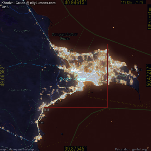
Analysis of Khodzhi-Gasan night lights 2016
Square area 10x10 km:
 25.85%
90-99
18.03%80-89
11.9%70-79
8.67%60-69
6.63%50-59
3.57%40-49
3.4%30-39
10.2%20-29
9.18%10-19
2.55%0-9
0%Square area 50x50 km:
6.04%90-99
6.52%80-89
5.04%70-79
5.1%60-69
6%50-59
4.51%40-49
3.92%30-39
5.05%20-29
6.83%10-19
14.39%0-9
36.6%Clear (daylight) street map image can be seen on geolist.org.
Map coordinates:
40° 56' 46.1" North, 49° 3' 57.3" East
40° 24' 46.5" North, 49° 46' 8.5" East
39° 52' 31.6" North, 50° 28' 19.8" East
Some cities around Khodzhi-Gasan sort by population:
• Baku
11.1 km =6.9 mi,  110°
110°
• Bilajari
4.7 km =2.9 mi,  41°
41°
• Khirdalan
4.1 km =2.5 mi,  343°
343°
• Lökbatan
10.2 km =6.3 mi,  197°
197°
• Binagadi
7.7 km =4.8 mi, 40°
• Badamdar
8.6 km =5.3 mi,  159°
159°
• Balakhani
13.9 km =8.6 mi,  66°
66°
• Qobu
4.8 km =3 mi,  259°
259°
585940 (p: 5,089)
Sources (retrieved 2019-11-25):
» Earth at Night: Flat Maps 2012, 2016