Qobu night lights from space
Night Light of Qobu (Abşeron) from space (Azerbaijan) Src. Average luminocity for 10x10km area is 40.0272% and for 50x50km: 31.4119%.
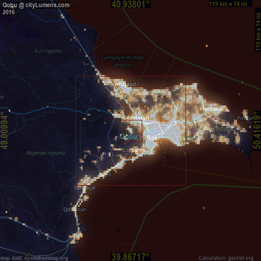
Analysis of Qobu night lights 2016
Square area 10x10 km:
100  2.89%
2.89%
90-99 4.93%
80-89 6.46%
70-79 4.93%
60-69 6.8%
50-59 5.27%
40-49 5.95%
30-39 13.78%
20-29 20.07%
10-19 22.96%
0-9 5.95%
2.89%90-99
4.93%80-89
6.46%70-79
4.93%60-69
6.8%50-59
5.27%40-49
5.95%30-39
13.78%20-29
20.07%10-19
22.96%0-9
5.95%Square area 50x50 km:
100 5.85%
90-99 6.07%
80-89 4.33%
70-79 4.75%
60-69 4.75%
50-59 3.71%
40-49 3.32%
30-39 4.88%
20-29 6.54%
10-19 13.79%
0-9 42.02%
5.85%90-99
6.07%80-89
4.33%70-79
4.75%60-69
4.75%50-59
3.71%40-49
3.32%30-39
4.88%20-29
6.54%10-19
13.79%0-9
42.02%Clear (daylight) street map image can be seen on geolist.org.
Map coordinates:
40° 56' 16.8" North, 49° 0' 35.8" East
40° 24' 17" North, 49° 42' 47" East
39° 52' 1.8" North, 50° 24' 58.3" East
Some cities around Qobu sort by population:
• Baku
15.5 km =9.6 mi,  101°
101°
• Bilajari
9 km =5.6 mi,  60°
60°
• Khirdalan
6 km =3.7 mi,  36°
36°
• Lökbatan
9 km =5.6 mi,  168°
168°
• Binagadi
11.9 km =7.4 mi,  54°
54°
• Badamdar
10.6 km =6.6 mi,  132°
132°
• Saray
14.3 km =8.9 mi,  1°
1°
• Khodzhi-Gasan
4.8 km =3 mi,  79°
79°
585838 (p: 7,377)
Sources (retrieved 2019-11-25):
» Earth at Night: Flat Maps 2012, 2016