Badamdar night lights from space
Night Light of Badamdar (Baki) from space (Azerbaijan) Src. Average luminocity for 10x10km area is 71.9167% and for 50x50km: 31.6686%.
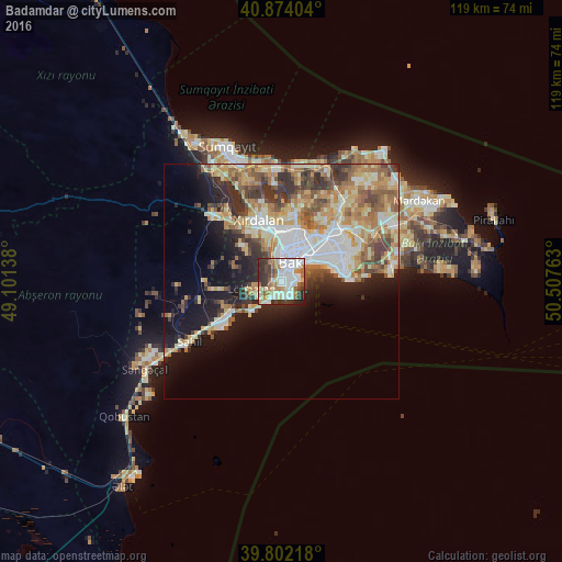
Analysis of Badamdar night lights 2016
Square area 10x10 km:
 20.24%
90-99
21.6%80-89
8.33%70-79
5.78%60-69
10.54%50-59
6.29%40-49
5.78%30-39
10.88%20-29
9.35%10-19
1.19%0-9
0%Square area 50x50 km:
5.72%90-99
6.11%80-89
4.86%70-79
4.76%60-69
5.5%50-59
4.31%40-49
3.66%30-39
4.63%20-29
5.17%10-19
10.41%0-9
44.86%Clear (daylight) street map image can be seen on geolist.org.
Map coordinates:
40° 52' 26.5" North, 49° 6' 5" East
40° 20' 24.9" North, 49° 48' 16.2" East
39° 48' 7.8" North, 50° 30' 27.5" East
Some cities around Badamdar sort by population:
• Baku
8.5 km =5.3 mi,  60°
60°
• Qaraçuxur
15.6 km =9.7 mi,  66°
66°
• Bilajari
11.6 km =7.2 mi,  0°
0°
• Khirdalan
12.7 km =7.9 mi,  340°
340°
• Lökbatan
6.2 km =3.9 mi,  254°
254°
• Binagadi
14.1 km =8.8 mi,  8°
8°
• Qobu
10.6 km =6.6 mi,  312°
312°
• Khodzhi-Gasan
8.6 km =5.3 mi, 339°
863761 (p: 11,398)
Sources (retrieved 2019-11-25):
» Earth at Night: Flat Maps 2012, 2016