Wantirna South night lights from space
Night Light of Wantirna South (Victoria) from space (Australia) Src. Average luminocity for 10x10km area is 75.7646% and for 50x50km: 45.0573%.
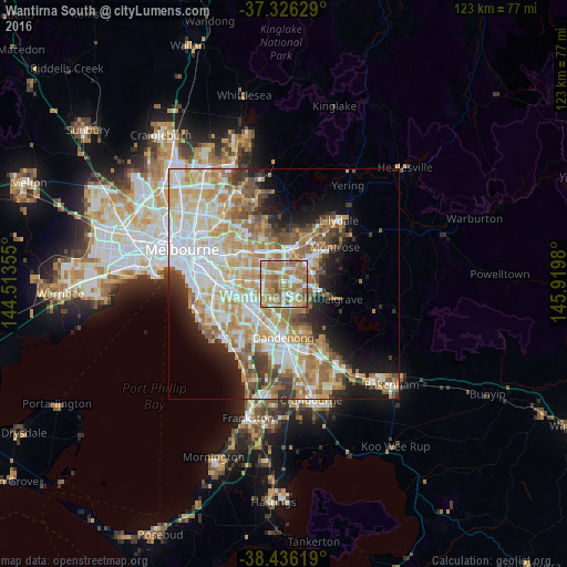
Analysis of Wantirna South night lights 2016
Square area 10x10 km:
 14.94%
90-99
12.82%80-89
8.12%70-79
15.91%60-69
34.9%50-59
12.5%40-49
0.81%30-39
0%20-29
0%10-19
0%0-9
0%Square area 50x50 km:
10.43%90-99
10.01%80-89
5.5%70-79
8.5%60-69
7.78%50-59
5.91%40-49
4.05%30-39
3.44%20-29
4.47%10-19
8.28%0-9
31.62%Clear (daylight) street map image can be seen on geolist.org.
Map coordinates:
37° 19' 34.6" South, 144° 30' 48.8" East
37° 52' 60" South, 145° 13' 0" East
38° 26' 10.3" South, 145° 55' 11.3" East
Some cities around Wantirna South sort by population:
• Glen Waverley
4.6 km =2.9 mi,  277°
277°
• Rowville
5.7 km =3.5 mi,  165°
165°
• Wheelers Hill
3.5 km =2.2 mi,  237°
237°
• Bayswater
5.7 km =3.5 mi,  49°
49°
• Vermont South
4.1 km =2.5 mi,  313°
313°
• Vermont
5.6 km =3.5 mi,  339°
339°
• Knoxfield
3 km =1.9 mi,  103°
103°
• Scoresby
2.4 km =1.5 mi,  141°
141°
2144728 (p: 19,081)
Sources (retrieved 2019-11-25):
» Earth at Night: Flat Maps 2012, 2016