Knoxfield night lights from space
Night Light of Knoxfield (Victoria) from space (Australia) Src. Average luminocity for 10x10km area is 69.0114% and for 50x50km: 42.5553%.
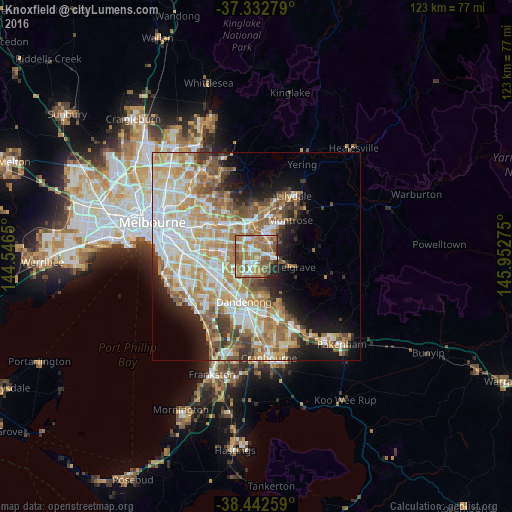
Analysis of Knoxfield night lights 2016
Square area 10x10 km:
 12.99%
90-99
11.04%80-89
5.68%70-79
12.34%60-69
25.81%50-59
18.83%40-49
5.19%30-39
1.79%20-29
5.36%10-19
0.97%0-9
0%Square area 50x50 km:
8.9%90-99
9.45%80-89
5.28%70-79
8.23%60-69
7.84%50-59
5.92%40-49
4.06%30-39
3.19%20-29
4.31%10-19
8.48%0-9
34.33%Clear (daylight) street map image can be seen on geolist.org.
Map coordinates:
37° 19' 58" South, 144° 32' 47.4" East
37° 53' 23.2" South, 145° 14' 58.6" East
38° 26' 33.3" South, 145° 57' 9.9" East
Some cities around Knoxfield sort by population:
• Rowville
5 km =3.1 mi,  196°
196°
• Ferntree Gully
4.1 km =2.5 mi,  81°
81°
• Boronia
3.9 km =2.4 mi,  49°
49°
• Wheelers Hill
5.9 km =3.7 mi,  258°
258°
• Wantirna South
3 km =1.9 mi,  283°
283°
• Wantirna
5.3 km =3.3 mi,  326°
326°
• Bayswater
4.7 km =2.9 mi,  18°
18°
• Scoresby
1.8 km =1.1 mi,  231°
231°
8348488 (p: 7,254)
Sources (retrieved 2019-11-25):
» Earth at Night: Flat Maps 2012, 2016