Wheelers Hill night lights from space
Night Light of Wheelers Hill (Victoria) from space (Australia) Src. Average luminocity for 10x10km area is 80.9367% and for 50x50km: 47.0944%.
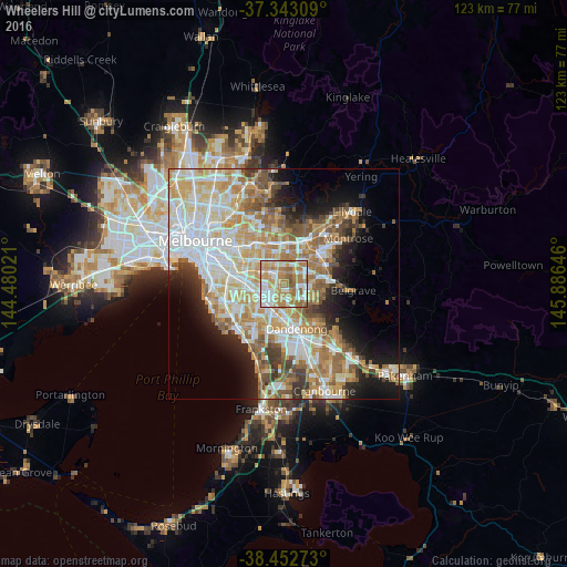
Analysis of Wheelers Hill night lights 2016
Square area 10x10 km:
 22.08%
90-99
18.99%80-89
6.49%70-79
18.34%60-69
26.14%50-59
7.47%40-49
0.49%30-39
0%20-29
0%10-19
0%0-9
0%Square area 50x50 km:
11.46%90-99
10.52%80-89
5.87%70-79
8.71%60-69
7.65%50-59
6.02%40-49
4%30-39
3.34%20-29
4.71%10-19
8.63%0-9
29.08%Clear (daylight) street map image can be seen on geolist.org.
Map coordinates:
37° 20' 35.1" South, 144° 28' 48.8" East
37° 54' 0" South, 145° 10' 60" East
38° 27' 9.8" South, 145° 53' 11.3" East
Some cities around Wheelers Hill sort by population:
• Glen Waverley
2.9 km =1.8 mi,  326°
326°
• Rowville
5.7 km =3.5 mi,  130°
130°
• Mount Waverley
5.4 km =3.4 mi,  298°
298°
• Wantirna South
3.5 km =2.2 mi,  57°
57°
• Mulgrave
3.2 km =2 mi,  189°
189°
• Vermont South
4.7 km =2.9 mi,  359°
359°
• Noble Park North
5.6 km =3.5 mi,  171°
171°
• Scoresby
4.4 km =2.7 mi,  90°
90°
2143887 (p: 19,369)
Sources (retrieved 2019-11-25):
» Earth at Night: Flat Maps 2012, 2016