Glebe night lights from space
Night Light of Glebe (New South Wales) from space (Australia) Src. Average luminocity for 10x10km area is 93.4108% and for 50x50km: 44.3499%.
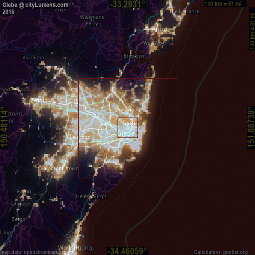
Analysis of Glebe night lights 2016
Square area 10x10 km:
 48.78%
90-99
25.7%80-89
9.79%70-79
11.36%60-69
3.85%50-59
0.52%40-49
0%30-39
0%20-29
0%10-19
0%0-9
0%Square area 50x50 km:
10.77%90-99
11.57%80-89
5.61%70-79
6.8%60-69
7.97%50-59
3.91%40-49
2.54%30-39
3.56%20-29
5.15%10-19
8.85%0-9
33.25%Clear (daylight) street map image can be seen on geolist.org.
Map coordinates:
33° 17' 35.2" South, 150° 28' 52.1" East
33° 52' 43.8" South, 151° 11' 3.3" East
34° 27' 38.1" South, 151° 53' 14.6" East
Some cities around Glebe sort by population:
• Newtown
2.3 km =1.4 mi,  195°
195°
• Pyrmont
1.3 km =0.8 mi,  42°
42°
• Camperdown
1.4 km =0.9 mi,  211°
211°
• Haymarket
1.9 km =1.2 mi,  89°
89°
• Annandale
1.7 km =1.1 mi,  252°
252°
• Chippendale
1.5 km =0.9 mi,  125°
125°
• Ultimo
1.2 km =0.7 mi,  81°
81°
• Lilyfield
1.8 km =1.1 mi,  283°
283°
2165450 (p: 11,525)
Sources (retrieved 2019-11-25):
» Earth at Night: Flat Maps 2012, 2016