Haymarket night lights from space
Night Light of Haymarket (New South Wales) from space (Australia) Src. Average luminocity for 10x10km area is 90.0437% and for 50x50km: 41.3139%.
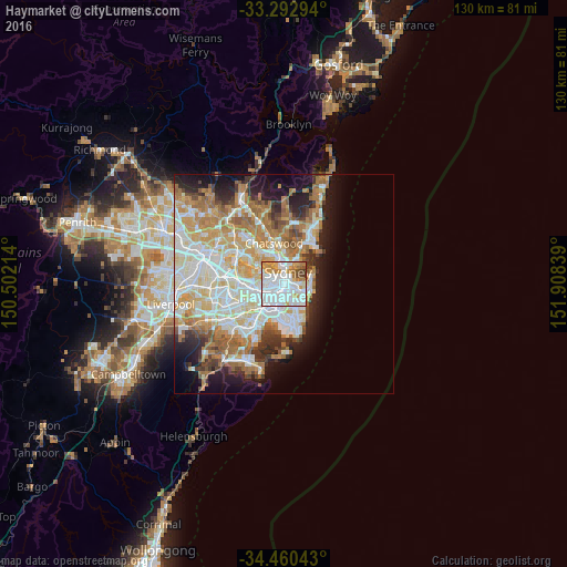
Analysis of Haymarket night lights 2016
Square area 10x10 km:
 45.8%
45.8%90-99
24.48%80-89
3.15%70-79
13.81%60-69
7.17%50-59
1.92%40-49
3.15%30-39
0.52%20-29
0%10-19
0%0-9
0%Square area 50x50 km:
9.79%90-99
10.47%80-89
5.11%70-79
6.62%60-69
7.85%50-59
3.65%40-49
2.49%30-39
3.44%20-29
4.88%10-19
8.59%0-9
37.13%Clear (daylight) street map image can be seen on geolist.org.
Map coordinates:
33° 17' 34.6" South, 150° 30' 7.7" East
33° 52' 43.2" South, 151° 12' 18.9" East
34° 27' 37.5" South, 151° 54' 30.2" East
Some cities around Haymarket sort by population:
• Sydney
1.2 km =0.7 mi,  8°
8°
• Sydney Central Business District
1.6 km =1 mi, 8°
• Surry Hills
0.9 km =0.6 mi,  128°
128°
• Pyrmont
1.4 km =0.9 mi,  313°
313°
• Redfern
1.6 km =1 mi,  183°
183°
• Darlinghurst
1.3 km =0.8 mi,  93°
93°
• Chippendale
1.1 km =0.7 mi,  218°
218°
• Ultimo
0.8 km =0.5 mi,  282°
282°
2163755 (p: 9,587)
Sources (retrieved 2019-11-25):
» Earth at Night: Flat Maps 2012, 2016