Lilyfield night lights from space
Night Light of Lilyfield (New South Wales) from space (Australia) Src. Average luminocity for 10x10km area is 93.042% and for 50x50km: 46.439%.
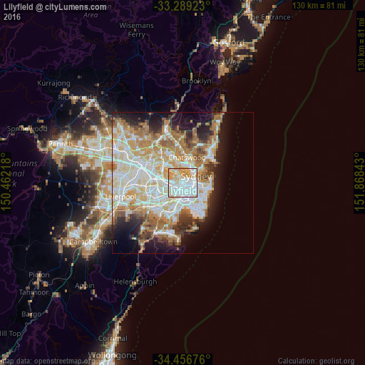
Analysis of Lilyfield night lights 2016
Square area 10x10 km:
 46.85%
90-99
25%80-89
10.66%70-79
15.73%60-69
1.75%50-59
0%40-49
0%30-39
0%20-29
0%10-19
0%0-9
0%Square area 50x50 km:
11.18%90-99
12.12%80-89
6.15%70-79
7.09%60-69
8.25%50-59
4.12%40-49
2.63%30-39
3.68%20-29
5.33%10-19
9.25%0-9
30.21%Clear (daylight) street map image can be seen on geolist.org.
Map coordinates:
33° 17' 21.2" South, 150° 27' 43.8" East
33° 52' 30" South, 151° 9' 55.1" East
34° 27' 24.3" South, 151° 52' 6.3" East
Some cities around Lilyfield sort by population:
• Leichhardt
1.3 km =0.8 mi,  221°
221°
• Glebe
1.8 km =1.1 mi,  103°
103°
• Camperdown
1.9 km =1.2 mi,  147°
147°
• Annandale
0.9 km =0.6 mi,  172°
172°
• Rozelle
1.6 km =1 mi,  17°
17°
• Petersham
2.4 km =1.5 mi,  203°
203°
• Stanmore
2.1 km =1.3 mi,  182°
182°
• Haberfield
2.2 km =1.4 mi,  245°
245°
2207762 (p: 7,594)
Sources (retrieved 2019-11-25):
» Earth at Night: Flat Maps 2012, 2016