Chippendale night lights from space
Night Light of Chippendale (New South Wales) from space (Australia) Src. Average luminocity for 10x10km area is 92.8462% and for 50x50km: 42.0821%.
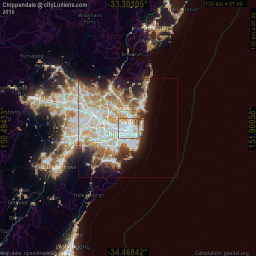
Analysis of Chippendale night lights 2016
Square area 10x10 km:
 50.87%
90-99
26.75%80-89
4.2%70-79
9.62%60-69
5.07%50-59
1.22%40-49
2.27%30-39
0%20-29
0%10-19
0%0-9
0%Square area 50x50 km:
10.04%90-99
10.79%80-89
5.38%70-79
6.67%60-69
7.81%50-59
3.72%40-49
2.51%30-39
3.37%20-29
4.9%10-19
8.12%0-9
36.7%Clear (daylight) street map image can be seen on geolist.org.
Map coordinates:
33° 18' 3.8" South, 150° 29' 39.6" East
33° 53' 12.2" South, 151° 11' 50.8" East
34° 28' 6.3" South, 151° 54' 2.1" East
Some cities around Chippendale sort by population:
• Surry Hills
1.5 km =0.9 mi,  76°
76°
• Pyrmont
1.9 km =1.2 mi,  350°
350°
• Redfern
0.9 km =0.6 mi,  137°
137°
• Glebe
1.5 km =0.9 mi,  305°
305°
• Camperdown
2 km =1.2 mi,  260°
260°
• Haymarket
1.1 km =0.7 mi,  38°
38°
• Ultimo
1.1 km =0.7 mi,  358°
358°
• Alexandria
1.5 km =0.9 mi,  172°
172°
2171589 (p: 8,936)
Sources (retrieved 2019-11-25):
» Earth at Night: Flat Maps 2012, 2016