Pyrmont night lights from space
Night Light of Pyrmont (New South Wales) from space (Australia) Src. Average luminocity for 10x10km area is 90.9091% and for 50x50km: 42.9388%.
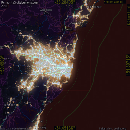
Analysis of Pyrmont night lights 2016
Square area 10x10 km:
 44.58%
90-99
23.78%80-89
6.29%70-79
17.13%60-69
5.59%50-59
1.05%40-49
1.57%30-39
0%20-29
0%10-19
0%0-9
0%Square area 50x50 km:
10.19%90-99
10.99%80-89
5.48%70-79
6.71%60-69
7.98%50-59
3.77%40-49
2.51%30-39
3.6%20-29
5.05%10-19
9.02%0-9
34.71%Clear (daylight) street map image can be seen on geolist.org.
Map coordinates:
33° 17' 2.6" South, 150° 29' 27.2" East
33° 52' 11.5" South, 151° 11' 38.5" East
34° 27' 6" South, 151° 53' 49.7" East
Some cities around Pyrmont sort by population:
• Sydney
1.2 km =0.7 mi,  79°
79°
• Sydney Central Business District
1.4 km =0.9 mi,  66°
66°
• Surry Hills
2.3 km =1.4 mi,  131°
131°
• Glebe
1.3 km =0.8 mi,  222°
222°
• Balmain
1.9 km =1.2 mi,  329°
329°
• Haymarket
1.4 km =0.9 mi, 133°
• Chippendale
1.9 km =1.2 mi,  170°
170°
• Ultimo
0.9 km =0.6 mi,  160°
160°
2152339 (p: 13,549)
Sources (retrieved 2019-11-25):
» Earth at Night: Flat Maps 2012, 2016