Gladesville night lights from space
Night Light of Gladesville (New South Wales) from space (Australia) Src. Average luminocity for 10x10km area is 86.8059% and for 50x50km: 50.3387%.
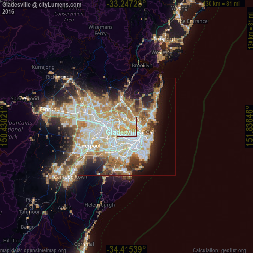
Analysis of Gladesville night lights 2016
Square area 10x10 km:
 21.85%
90-99
22.03%80-89
21.5%70-79
31.29%60-69
3.32%50-59
0%40-49
0%30-39
0%20-29
0%10-19
0%0-9
0%Square area 50x50 km:
12.01%90-99
13.09%80-89
6.85%70-79
8.03%60-69
9.12%50-59
4.29%40-49
2.75%30-39
3.92%20-29
5.51%10-19
8.68%0-9
25.77%Clear (daylight) street map image can be seen on geolist.org.
Map coordinates:
33° 14' 50.2" South, 150° 25' 48.8" East
33° 49' 60" South, 151° 7' 60" East
34° 24' 55.4" South, 151° 50' 11.3" East
Some cities around Gladesville sort by population:
• Ryde
3 km =1.9 mi,  302°
302°
• Concord
3.1 km =1.9 mi,  240°
240°
• Drummoyne
2.9 km =1.8 mi,  136°
136°
• North Ryde
4.1 km =2.5 mi,  348°
348°
• Lane Cove
3.7 km =2.3 mi,  57°
57°
• Hunters Hill
1.2 km =0.7 mi,  95°
95°
• Five Dock
3.8 km =2.4 mi,  185°
185°
• Abbotsford
1.8 km =1.1 mi,  195°
195°
2208292 (p: 11,673)
Sources (retrieved 2019-11-25):
» Earth at Night: Flat Maps 2012, 2016