North Ryde night lights from space
Night Light of North Ryde (New South Wales) from space (Australia) Src. Average luminocity for 10x10km area is 81.4895% and for 50x50km: 49.5811%.
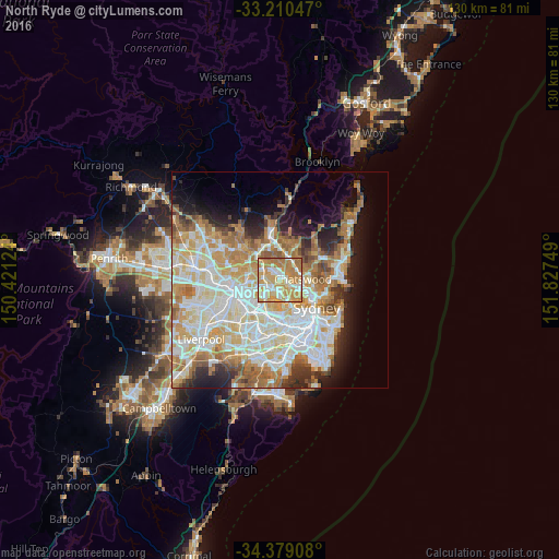
Analysis of North Ryde night lights 2016
Square area 10x10 km:
 12.76%
90-99
20.28%80-89
14.16%70-79
32.52%60-69
19.23%50-59
1.05%40-49
0%30-39
0%20-29
0%10-19
0%0-9
0%Square area 50x50 km:
11.84%90-99
13.08%80-89
7.04%70-79
8.13%60-69
8.8%50-59
4.2%40-49
2.51%30-39
3.47%20-29
4.99%10-19
7.61%0-9
28.35%Clear (daylight) street map image can be seen on geolist.org.
Map coordinates:
33° 12' 37.7" South, 150° 25' 16.5" East
33° 47' 48.4" South, 151° 7' 27.7" East
34° 22' 44.7" South, 151° 49' 39" East
Some cities around North Ryde sort by population:
• Ryde
3 km =1.9 mi,  214°
214°
• Eastwood
4.1 km =2.5 mi,  277°
277°
• Marsfield
2.7 km =1.7 mi,  320°
320°
• Gladesville
4.1 km =2.5 mi,  168°
168°
• Lane Cove North
4 km =2.5 mi,  103°
103°
• Lindfield
4.2 km =2.6 mi,  69°
69°
• Macquarie Park
1.8 km =1.1 mi,  9°
9°
• West Pymble
3.4 km =2.1 mi, 13°
7281782 (p: 10,827)
Sources (retrieved 2019-11-25):
» Earth at Night: Flat Maps 2012, 2016