Drummoyne night lights from space
Night Light of Drummoyne (New South Wales) from space (Australia) Src. Average luminocity for 10x10km area is 90.1643% and for 50x50km: 48.113%.
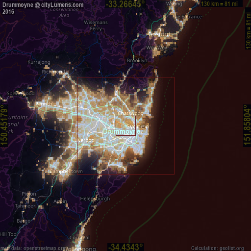
Analysis of Drummoyne night lights 2016
Square area 10x10 km:
 34.62%
90-99
24.65%80-89
14.86%70-79
24.13%60-69
1.75%50-59
0%40-49
0%30-39
0%20-29
0%10-19
0%0-9
0%Square area 50x50 km:
11.54%90-99
12.53%80-89
6.57%70-79
7.31%60-69
8.44%50-59
4.26%40-49
2.66%30-39
3.88%20-29
5.53%10-19
9.23%0-9
28.03%Clear (daylight) street map image can be seen on geolist.org.
Map coordinates:
33° 15' 59.2" South, 150° 27' 6.4" East
33° 51' 8.5" South, 151° 9' 17.7" East
34° 26' 3.5" South, 151° 51' 28.9" East
Some cities around Drummoyne sort by population:
• Gladesville
2.9 km =1.8 mi,  316°
316°
• Balmain
2.6 km =1.6 mi,  95°
95°
• Hunters Hill
2.2 km =1.4 mi,  337°
337°
• Five Dock
2.9 km =1.8 mi,  235°
235°
• Rozelle
1.8 km =1.1 mi,  124°
124°
• Lilyfield
2.7 km =1.7 mi,  159°
159°
• Greenwich
3 km =1.9 mi,  61°
61°
• Abbotsford
2.5 km =1.6 mi,  278°
278°
2207783 (p: 11,718)
Sources (retrieved 2019-11-25):
» Earth at Night: Flat Maps 2012, 2016