Lane Cove night lights from space
Night Light of Lane Cove (New South Wales) from space (Australia) Src. Average luminocity for 10x10km area is 82.8497% and for 50x50km: 45.504%.
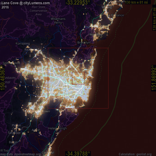
Analysis of Lane Cove night lights 2016
Square area 10x10 km:
 15.56%
90-99
21.68%80-89
14.16%70-79
30.77%60-69
16.43%50-59
1.4%40-49
0%30-39
0%20-29
0%10-19
0%0-9
0%Square area 50x50 km:
11.1%90-99
12.06%80-89
6.09%70-79
7.02%60-69
8.01%50-59
3.85%40-49
2.39%30-39
3.49%20-29
4.99%10-19
7.85%0-9
33.17%Clear (daylight) street map image can be seen on geolist.org.
Map coordinates:
33° 13' 46.3" South, 150° 27' 49.2" East
33° 48' 56.5" South, 151° 10' 0.4" East
34° 23' 52.4" South, 151° 52' 11.7" East
Some cities around Lane Cove sort by population:
• Chatswood
2.3 km =1.4 mi,  41°
41°
• Artarmon
1.5 km =0.9 mi,  94°
94°
• Hunters Hill
2.8 km =1.7 mi,  222°
222°
• Wollstonecraft
2.9 km =1.8 mi,  131°
131°
• Willoughby
3.2 km =2 mi,  68°
68°
• St Leonards
3 km =1.9 mi,  106°
106°
• Greenwich
3 km =1.9 mi,  150°
150°
• Naremburn
3.1 km =1.9 mi, 92°
2160625 (p: 10,646)
Sources (retrieved 2019-11-25):
» Earth at Night: Flat Maps 2012, 2016