Hunters Hill night lights from space
Night Light of Hunters Hill (New South Wales) from space (Australia) Src. Average luminocity for 10x10km area is 87.1031% and for 50x50km: 48.8999%.
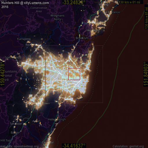
Analysis of Hunters Hill night lights 2016
Square area 10x10 km:
 23.08%
90-99
22.73%80-89
20.45%70-79
30.94%60-69
2.8%50-59
0%40-49
0%30-39
0%20-29
0%10-19
0%0-9
0%Square area 50x50 km:
11.79%90-99
12.71%80-89
6.74%70-79
7.61%60-69
8.56%50-59
4.24%40-49
2.65%30-39
3.87%20-29
5.51%10-19
8.65%0-9
27.66%Clear (daylight) street map image can be seen on geolist.org.
Map coordinates:
33° 14' 53.8" South, 150° 26' 34" East
33° 50' 3.6" South, 151° 8' 45.2" East
34° 24' 58.9" South, 151° 50' 56.5" East
Some cities around Hunters Hill sort by population:
• Drummoyne
2.2 km =1.4 mi,  157°
157°
• Gladesville
1.2 km =0.7 mi,  275°
275°
• Lane Cove North
3.7 km =2.3 mi,  30°
30°
• Lane Cove
2.8 km =1.7 mi,  42°
42°
• Artarmon
4 km =2.5 mi,  60°
60°
• Rozelle
3.8 km =2.4 mi,  142°
142°
• Greenwich
3.5 km =2.2 mi,  99°
99°
• Abbotsford
2.3 km =1.4 mi,  225°
225°
2207809 (p: 9,357)
Sources (retrieved 2019-11-25):
» Earth at Night: Flat Maps 2012, 2016