Concord night lights from space
Night Light of Concord (New South Wales) from space (Australia) Src. Average luminocity for 10x10km area is 90.2465% and for 50x50km: 54.5145%.
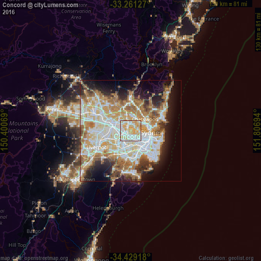
Analysis of Concord night lights 2016
Square area 10x10 km:
 28.15%
90-99
27.45%80-89
24.65%70-79
19.76%60-69
0%50-59
0%40-49
0%30-39
0%20-29
0%10-19
0%0-9
0%Square area 50x50 km:
12.71%90-99
14.12%80-89
7.38%70-79
8.68%60-69
9.94%50-59
5.21%40-49
3.16%30-39
4.28%20-29
6.15%10-19
9.35%0-9
19.03%Clear (daylight) street map image can be seen on geolist.org.
Map coordinates:
33° 15' 40.6" South, 150° 24' 2.5" East
33° 50' 50" South, 151° 6' 13.7" East
34° 25' 45" South, 151° 48' 25" East
Some cities around Concord sort by population:
• Ryde
3.2 km =2 mi,  3°
3°
• Rhodes
2.7 km =1.7 mi,  327°
327°
• Gladesville
3.1 km =1.9 mi,  60°
60°
• Five Dock
3.2 km =2 mi,  133°
133°
• Homebush West
3.8 km =2.4 mi,  243°
243°
• Wentworth Point
3.3 km =2.1 mi,  303°
303°
• Homebush
2.9 km =1.8 mi,  221°
221°
• Abbotsford
2.2 km =1.4 mi,  94°
94°
2170852 (p: 14,353)
Sources (retrieved 2019-11-25):
» Earth at Night: Flat Maps 2012, 2016