Abbotsford night lights from space
Night Light of Abbotsford (New South Wales) from space (Australia) Src. Average luminocity for 10x10km area is 89.2675% and for 50x50km: 51.2778%.
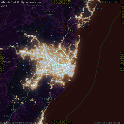
Analysis of Abbotsford night lights 2016
Square area 10x10 km:
 28.32%
90-99
24.83%80-89
20.98%70-79
24.83%60-69
1.05%50-59
0%40-49
0%30-39
0%20-29
0%10-19
0%0-9
0%Square area 50x50 km:
12.12%90-99
13.22%80-89
7%70-79
8.21%60-69
9.25%50-59
4.52%40-49
2.86%30-39
4.04%20-29
5.84%10-19
9.3%0-9
23.65%Clear (daylight) street map image can be seen on geolist.org.
Map coordinates:
33° 15' 46.6" South, 150° 25' 29.6" East
33° 50' 56" South, 151° 7' 40.8" East
34° 25' 51" South, 151° 49' 52.1" East
Some cities around Abbotsford sort by population:
• Ryde
3.9 km =2.4 mi,  328°
328°
• Concord
2.2 km =1.4 mi,  274°
274°
• Drummoyne
2.5 km =1.6 mi,  98°
98°
• Gladesville
1.8 km =1.1 mi,  15°
15°
• Croydon
4 km =2.5 mi,  195°
195°
• Hunters Hill
2.3 km =1.4 mi,  45°
45°
• Five Dock
2.1 km =1.3 mi,  177°
177°
• Concord West
3.9 km =2.4 mi, 271°
2178377 (p: 5,316)
Sources (retrieved 2019-11-25):
» Earth at Night: Flat Maps 2012, 2016