Forestville night lights from space
Night Light of Forestville (New South Wales) from space (Australia) Src. Average luminocity for 10x10km area is 62.9927% and for 50x50km: 37.4652%.
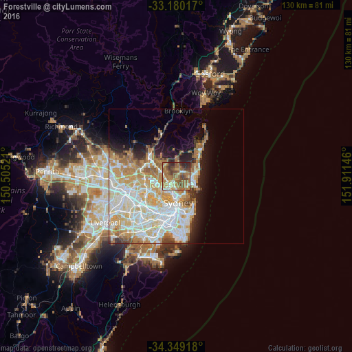
Analysis of Forestville night lights 2016
Square area 10x10 km:
 3.66%
3.66%90-99
8.79%80-89
6.41%70-79
8.79%60-69
35.35%50-59
13.37%40-49
11.17%30-39
8.06%20-29
4.4%10-19
0%0-9
0%Square area 50x50 km:
9.29%90-99
10.04%80-89
4.87%70-79
6.17%60-69
6.7%50-59
2.75%40-49
1.91%30-39
2.55%20-29
3.49%10-19
5.98%0-9
46.26%Clear (daylight) street map image can be seen on geolist.org.
Map coordinates:
33° 10' 48.6" South, 150° 30' 18.8" East
33° 46' 0" South, 151° 12' 30" East
34° 20' 57" South, 151° 54' 41.3" East
Some cities around Forestville sort by population:
• Chatswood
4.4 km =2.7 mi,  211°
211°
• Frenchs Forest
2.5 km =1.6 mi,  33°
33°
• Killara
4.3 km =2.7 mi,  270°
270°
• Roseville
3 km =1.9 mi,  231°
231°
• Lindfield
4.3 km =2.7 mi,  244°
244°
• Belrose
3 km =1.9 mi,  3°
3°
• Allambie Heights
3.8 km =2.4 mi,  89°
89°
• Willoughby
4.3 km =2.7 mi,  191°
191°
2208302 (p: 8,185)
Sources (retrieved 2019-11-25):
» Earth at Night: Flat Maps 2012, 2016