Lindfield night lights from space
Night Light of Lindfield (New South Wales) from space (Australia) Src. Average luminocity for 10x10km area is 75.9725% and for 50x50km: 43.3097%.
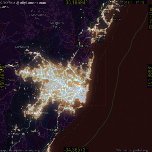
Analysis of Lindfield night lights 2016
Square area 10x10 km:
 10.26%
90-99
17.4%80-89
10.07%70-79
20.33%60-69
29.12%50-59
8.06%40-49
3.11%30-39
1.65%20-29
0%10-19
0%0-9
0%Square area 50x50 km:
10.68%90-99
11.71%80-89
5.91%70-79
6.73%60-69
7.45%50-59
3.6%40-49
2.12%30-39
3.05%20-29
4.47%10-19
6.58%0-9
37.71%Clear (daylight) street map image can be seen on geolist.org.
Map coordinates:
33° 11' 49" South, 150° 27' 48.8" East
33° 46' 60" South, 151° 10' 0" East
34° 21' 56.6" South, 151° 52' 11.3" East
Some cities around Lindfield sort by population:
• Chatswood
2.4 km =1.5 mi,  140°
140°
• Lane Cove North
2.5 km =1.6 mi,  180°
180°
• Lane Cove
3.6 km =2.2 mi, 179°
• Killara
2 km =1.2 mi,  347°
347°
• Roseville
1.5 km =0.9 mi,  90°
90°
• Macquarie Park
3.6 km =2.2 mi,  274°
274°
• Gordon
3.4 km =2.1 mi,  335°
335°
• West Pymble
3.6 km =2.2 mi,  301°
301°
2160114 (p: 9,616)
Sources (retrieved 2019-11-25):
» Earth at Night: Flat Maps 2012, 2016