Willoughby night lights from space
Night Light of Willoughby (New South Wales) from space (Australia) Src. Average luminocity for 10x10km area is 74.479% and for 50x50km: 40.6841%.
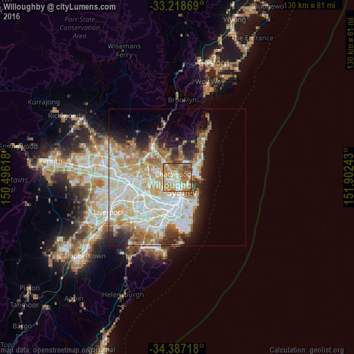
Analysis of Willoughby night lights 2016
Square area 10x10 km:
 10.66%
90-99
14.69%80-89
8.39%70-79
19.93%60-69
32.52%50-59
8.22%40-49
4.72%30-39
0.87%20-29
0%10-19
0%0-9
0%Square area 50x50 km:
9.74%90-99
10.57%80-89
5.31%70-79
6.52%60-69
7.57%50-59
3.4%40-49
2.13%30-39
3.19%20-29
4.54%10-19
6.99%0-9
40.02%Clear (daylight) street map image can be seen on geolist.org.
Map coordinates:
33° 13' 7.3" South, 150° 29' 46.2" East
33° 48' 17.7" South, 151° 11' 57.5" East
34° 23' 13.8" South, 151° 54' 8.7" East
Some cities around Willoughby sort by population:
• Chatswood
1.6 km =1 mi,  290°
290°
• Lane Cove North
3 km =1.9 mi,  268°
268°
• Roseville
2.8 km =1.7 mi,  328°
328°
• Artarmon
2 km =1.2 mi,  228°
228°
• Cammeray
2.4 km =1.5 mi,  139°
139°
• St Leonards
2.1 km =1.3 mi,  182°
182°
• Northbridge
1.9 km =1.2 mi,  118°
118°
• Naremburn
1.3 km =0.8 mi,  174°
174°
6949388 (p: 6,451)
Sources (retrieved 2019-11-25):
» Earth at Night: Flat Maps 2012, 2016